
This item has been sold, but you can enter your email address to be notified if another example becomes available.


|
||

|

|
|

|
Stock# 70920
Description
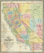
Large color-printed folding map of the roads in California in 1932, produced by the State of California, Department of Public Works, Division of Highways.
The legend shows the following:
- United States Highway Route Numbers
- High type, improved or under contract [Red]
- Intermediate type, Improved or under contract [Yellow]
- Low type, Improved or under contract [Black]
- Unimproved [Black outline]
- Proposed Road [Dashed]
- Mileage between Points
The verso includes 10 inset road maps for California metropolitan areas and a further map of the main highways of the American West.
For reference, here is a 1934 edition of the map that we have previously sold: www.raremaps.com/gallery/detail/53667
Condition Description
Folding map. Some minor wear and toning at folds. Withal a very nice example. Some minor pen graffiti in the vicinity of Folsom and Stockton.
![(Southern California Aerial Photographs) [Collection of 9 Aerial Photographs of San Fernando Valley, Van Nuys, and Burbank]](https://storage.googleapis.com/raremaps/img/small/94783.jpg)
![Mexico [Texas on the Eve of Independence]](https://storage.googleapis.com/raremaps/img/small/84917.jpg)