


|
||

|

|
|

|
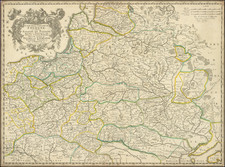
Attractive engraved antique map of Prussia (part of modern-day Poland and Germany), published by David Burr in New York in 1836.
The map extends from the Lower Rhine in the west to central Poland in the east. Numerous towns are named, such as Leipzig, Breslau, Dresden, etc.
David H. Burr studied law, passing the New York Bar Exam, and then surveying under Simeon DeWitt in New York. His first atlas was an atlas of New York State (1829), the second state atlas to be issued in the US (after Mills’ Atlas of South Carolina in 1826). In the 1830s, he served as the official topographer for the US Post Office, producing a series of rare and highly sought-after large-format state maps. He also created a map of the country’s postal routes, which features roads, canals, and railroads. Burr traveled to London to work with John Arrowsmith; together, they produced the American Atlas in 1839.
Upon his return to the States, Burr was appointed as a draftsman for the House of Representatives, where he worked until ca. 1841. He later worked for the Louisiana Survey and the Florida Survey. By 1850, he was back in Washington D. C., working on the census. In 1852, the Senate named Burr as the draftsman to compile maps from the Federal Surveys. In 1853, Burr traveled to San Francisco, perhaps as part of his work for the Senate. He was then named as the Surveyor General of Utah in 1855. However, he was unpopular there and returned to Washington D. C. by 1870. Burr is widely regarded as one of the most important names in the nineteenth-century American history of cartography.
![[ Holy Roman Empire ] A Newe Mape of Germany Newly Augmented by Iohn Speed Ano Dom: 1626](https://storage.googleapis.com/raremaps/img/small/68482.jpg)
![[Heightened in Gold!] Pas-Caart van de Oost Zee Verthoonende Alle de ghelgentheydt tusschen 't Eylandt Rugen ende Wyborg. Op nieuws oversien en verbeetert. . . 1665](https://storage.googleapis.com/raremaps/img/small/83731.jpg)