|
||

|

|
|

|
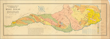
An Early Coast To Coast Map of the United States -- Republic of Texas
Fine map of the United States from Coast to Coast, also showing the Republic of Texas just two years after its declaration of independence in 1836.
During the 1820s to 1840s, the major French cartographic publishing houses generated some of the most outstanding and historically significant maps of the American west.
This map incorporates remarkable details from the early western explorations of Lewis & Clark, Long, and others, but pre-dating the explorations of John Fremont. The mythical rivers flowing across California, Utah and Nevada are shown, along with both Lake Timpanogos and Lake Teguayo. There is a massive Missouri Territory, dominating the upper Rocky Mountain and Plains regions.. Oregon Territory extends to encompass much of British Columbia.
Many fascinating placenames and mythical geological features in the west. Lots of Indians, early forts, and an early location of the Santa Fe Trail, although with an erroneous route.
Texas is shown as a Republic and includes excellent detail. Arkansas is shown in its widest format, extending to New Mexico.
![(Texas - Mexican War) Campaña Contra Los Americanos del Norte. Primera Parte [all issued]. Relación histórica de los Cuarenta Días que mandó en gefe el ejército del Norte el E. Sr. general de division Don Mariano Arista, Escrita por un oficial de infantería](https://storage.googleapis.com/raremaps/img/small/95742.jpg)
![[The 13 United States] Charte uber die XIII vereinigte Staaten von Nord-America Entworfen duch F.L. Gussefeld . . . Ao 1784](https://storage.googleapis.com/raremaps/img/small/100144.jpg)