|
||

|

|
|

|
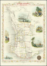
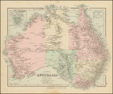
Exquisitely-Detailed Map of Australasia and the South Pacific -- Sea of Korea
Fine example of Walch's map of the Western Pacific and Southeast Asia, first published in Augsburg in 1802. It celebrates the routes and encounters of the recent European voyages to the region.
The map provides a plethora of place names in Australia, New Zealand, and the island Pacific. It stretches from Sumatra in the west to Pitcairn in the east, recently made famous by Bligh’s mutineers. New Zealand marks out the southern reaches of the map, with Japan and Korea in the north.
The Australian continent's outline is certainly recognizable, having been updated from the early editions to show improved knowledge of the southern coast of the continent. The uncertain shape of New Guinea on this map reflects what little charting had taken place by 1802. New Zealand is shown as two islands, based on James Cook’s and others’ charting utilizing a phenetic spelling of the Maori names for them.
The map has a simple oval cartouche in the upper right corner and a scale in the lower right. In the lower left is the following note:
On this map you will find the three sea trips of the Capt Cook, and other circumnavigators displayed; In order to show the direction in which they sailed, the lines designated by the travels were furnished with small posts [arrows].
The map reflects the booming German market for all things Pacific in the wake of Cook's voyages. The Germans themselves would start to explore to the region in the nineteenth century and the German Empire would eventually encompass German New Guinea (Papua New Guinea, Solomon Islands, Palau, Federated States of Micronesia, Nauru, Northern Mariana Islands, Marshall Islands, Samoa) from 1884 to 1919.
Exploring the Pacific
Cook is not just mentioned in the note in the lower left; the map is bursting with references to the area's exploration and includes tracks, with dates, of the voyages of several European explorers. The oldest is Tasman, whose first voyage is shown here. In 1642-3, Tasman led his ship along the south of Australia, round Tasmania, which he called Van Diemen’s Land after the governor of Batavia. Tasman was the first European to site Tasmania, New Zealand, Tonga, and the Fiji Islands.
Cook is certainly the most-represented explorer on this map, with all three of his epic voyages marked out. His first was in 1768-1771, when he went to Tahiti to observe the Transit of Venus in the company of Joseph Banks. The second, from 1772-5, was in search of the great southern continent, the existence of which he disproved by crossing the Arctic Circle three times. His third, and final, expedition, was to seek the Northwest Passage. He set off in 1776 and died in 1780, in Hawaii.
Cook followed in the wake of several other voyages in the early 1760s. These included Bougainville, who completed the first French circumnavigation. The British sent a series of naval officers to the Pacific, starting with Byron and followed by Wallis and Carteret. Both Byron and Wallis sailed in the Dolphin, the first ship to sail around the world twice.
A more recent voyage included on the map is that of “Capt. Marshall” in 1789, a reference to the Australia-to-China voyage of Masters Thomas Gilbert and William Marshall. Both men sailed with the First Fleet, bringing convicts to Australia. Then they were tasked by the East India Company to load up tea in Canton. Gilbert’s published account resulted in the names of Gilbert and Marshall being attached to two atolls.
Even more recent is the voyage of George Bass. Bass was a surgeon in the Royal Navy. He was assigned to the Reliance, where Matthew Flinders was serving. The two performed several surveying missions together and, by 1799, Bass had confirmed the existence of a strait between Tasmania and Australia.
Dutch Encounters with Australia
Although their routes are not marked, several other voyages are also memorialized in Australia. These are the result of Dutch East India Company voyages that encountered the north, west, and south coasts of the continent. In the north is Carpentaria, so named by Jan Cartensz after Peiter de Carpentier, the VOC governor of the East Indies in the early 1620s. Carstensz was not the first Dutchman in this area, however.
That would be Willem Janszoon on his voyage of 1605-6 in what is today Queensland. Janszoon was in command of the Duyfken, a Dutch East India Company (VOC) ship, and he explored the eastern shore of the Gulf of Carpentaria, just below the Cape York Peninsula. This venture was famously the first recorded European contact with Australia.
Continuing west around Australia, Arnhems Land refers to the Arnhem, a Dutch East India ship, which sighted the area in 1623. This was one of the two ships that sailed with Carstensz. To the west is G. F. de Witts Land, which recalls Gerrit Frederikszoon de Witt, captain of the Vianen, which sailed in 1628.
To the south is Endracht Land. The Endracht was the second recorded European ship to contact Australia (1616), and the first in western Australia. The Endracht was blown off course en route to the East Indies in that year. It was commanded by Dirk Hartog, whose name is on an island nearby. The crew commemorated their discovery by erecting a post with a pewter dish inscribed with their ship’s information—the earliest physical record that historians have of any European landing in Australia.
Houtmans Untiefen die Turteltaube and Edels Land both refer to the same voyage. Jacob d’Edel, in the Amsterdam, along with Frederik de Houtman in the Dordrecht came within sight of the western coast and called the stretch of land d’Edelsland. The Houtmans Abrolhos are an archipelago, as shown here with x marks surrounded by dots, and named for the navigator who sighted them, or at least it was Houtman who reported the islands to the VOC. It was here that the Batavia wrecked in 1629. Also included is the shoal sighted by and named for the Tortelduyf, which is labeled here as Turteltaube.
Out to sea is Trial Felsen. This tiny geographic feature recalls the abrupt end of the voyage of the English ship Trial. The ship stuck rocks in the dead of night. The survivors of the wreck managed to sail in two small craft to Batavia in July 1622 and report the dangerous, but hard to locate, obstructions.
Löwens Land is named for the Leeuwin, whose crew charted some of the southwest coastline in 1622; Flinders would later name Cape Leeuwin, the southwestern most point on the Australian mainland, after the ship. A note in the south mentions Peter Nuyts, or Pieter Nuyts, a Dutch navigator who commanded the Gulden Zeepaert along the southern coast in 1627.
The map shows Europe’s enduring interest in, and more recent increased presence in, the Pacific region. This map was published in 1802, 1816, 1820, 1824 and 1826, with amendments.
Johann, or Johannes, Walch (1757-1816) was a painter and engraver. He was well-known for painting miniature portraits, having trained in Geneva, Venice, and Rome. Walch published several atlases and sheet maps. As with his atlases, many of Walch’s maps were reprinted after his death.
![[Manila Bay] La Baie de Manille, Selon les Observations les plus recentes . . .](https://storage.googleapis.com/raremaps/img/small/59286.jpg)