|
||

|

|
|

|
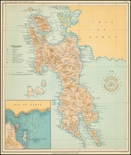
The Spice Map—Based on Smuggled Portuguese Manuscript Charts.
Rare English edition of Petrus Plancius's "Spice Map," first published in 1594, covering the Philippines and Maritime Southeast Asia, including the famed Spice Islands.
Plancius based his map on covertly-obtained Portuguese manuscript charts. The map is a vast improvement over previously printed maps of the region, with most of the islands well-delineated, well-placed, and correctly named.
The map is densely engraved with detail and cartographic decoration. Each island is thickly blanketed with toponyms. Some of the place names have were communicated to the mapmaker via Portuguese materials, but others were from earlier sources. For example, Beach in the lower southwest corner stems from Marco Polo.
New Guinea and the islands to the east are unfinished, with open coastlines to the south. This reflected the state of knowledge at the time, and the hypothesis that they might connect to a large southern continent.
While extraordinarily well-formed for the time, there are a few oddities in the map that have to do with it being a still little-known, to the Dutch, area. Palawan is confused with the Calamianes. The west coast of New Guinea is separated and shown as the island of Seram (Ceiram), which also has the Guinean port of Canam. This last detail would be repeated in later maps, such as those by Linschoten and Rossi.
In the seas, rhumb lines criss-cross the water, suggesting possible navigation. This navigational theme is echoed in the sailing ships that are in seas too. Beware, however, as there are many sea monsters dotting the map as well. A massive compass rose is a distinctive feature, as are the detailed strapwork cartouches housing the title, scale bars, and publication information.
In addition to the map's importance as an iconic illustration of the opening of the spice trade to Dutch traders, this map served as the model for Jodocus Hondius's Philippinae Insulae, the first printed map of the Philippine Islands.
This map appeared in the rare English edition of Linschoten's Itinerario: Iohn Huighen van Linschoten. His discours of voyages (London, 1598).
Spices and the East India trade
This map is known as the “Spice Map” for its illustration of nutmeg, clove, and sandalwood included along the bottom of the map. The map was published as a means of promoting the commercial importance and viability of prospective Dutch voyages to the Spice Islands.
Trade with the Indian subcontinent and the East Indies was a central focus for the Dutch when the map was made. The Moluccas, just west of Papua, were of importance for they were the vaunted Spice Islands, originally the only source in the world for nutmeg, mace, and cloves. The Portuguese were the first Europeans to gain power in the East Indies, trading for spices in the Moluccas and controlling the spice market in Europe.
The Dutch wanted in on the lucrative trade, but they also had to contend with the Portuguese. The first Dutch expedition, led by Cornelis de Houtman in 1595—the year after this map was published—avoided India, the Strait of Malacca, and the Moluccas—Portuguese strongholds—in favor of the Sunda Strait. The Dutch set up their trade centers on the island of Java, at Bantam and, later, Batavia. After Houtman, the second Dutch expedition (1598-1600) quickly set sail for the East Indies. It was followed by five others. In 1602, the most powerful of these merchants and the Dutch government, the States General, created the Dutch East India Company (VOC), a monopoly to control the East Indies trade.
States of the map
Günter Schilder notes three states of the Plancius edition of the map:
- State 1: Published by Cornelis Claesz in Amsterdam 1592–94, with the engraver named as ‘Ioannes à Doetechum fecit.’
- State 2: Published before 1609, with the engraver changed to ‘Joannes van Doetecum.’
- State 3: Published by Claes Janszoon Visscher in 1617, with the engravers name replaced by ‘CIVisscher exudabat Ao. 1617.’
The present map is a finely engraved copy of State 1, published in London in 1598 by John Wolfe and engraved by Richard Beckit. All states of the map are rare, but the earlier states, and especially one published for an English edition, like this example, are extraordinarily rare.
This is a particularly nice example of the Wolfe edition, with strong contrasts and the engraved guidelines preserved. We have seen a number of examples of the Wolfe in which the guidelines are almost completely obliterated by plate wear.
Petrus Plancius (1552-1622) was born Pieter Platevoet in Dranouter in West Flanders. He trained as a clergyman in Germany and England, but he was an expert not only in theology but in geography, cosmography, and navigation. After fleeing prosecution by the Inquisition in Brussels, Plancius settled in Amsterdam where he first began his forays into navigation and charting. As Amsterdam was a hub for trade, Plancius was able to access Portuguese charts, the most advanced in the world at that time. Plancius used these charts to become an expert in the sailing routes to India, knowledge that gained him opportunity. Plancius was one of the founders of the VOC, for whom he worked as their geographer. He also served on a Government Committee to review the equipment needed for exploratory expeditions.
![[Philippine Islands] Carte du Canal des Iles Philippines Par leque passe le Galion de Manille. Et les Iles voisines de ce canal / Kaart van het Kanaal in de Filippynsche Eilanden . . .](https://storage.googleapis.com/raremaps/img/small/76427.jpg)
![[ Philippine Islands ] This Pocket Map of Philippine Islands...](https://storage.googleapis.com/raremaps/img/small/94096.jpg)