This item has been sold, but you can enter your email address to be notified if another example becomes available.


|
||

|

|
|

|
Stock# 70831
Description
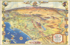
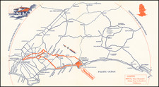
Detailed vintage map of San Pedro and western Long Beach, including the Port of Los Angeles terminals, published by the Automobile Club of Southern California.
The map includes an inset of the area between Downtown Los Angeles and San Pedro, with mileage for the routes indicated in circles along the way.
At the left is a key naming dozens of industrial plants in the area.
The map does not show the extension of the Fish Harbor sea wall that was underway in 1923, suggesting a date earlier than that.
Condition Description
Folding map. Minor wear at folds.