


|
||

|

|
|

|
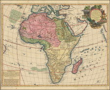
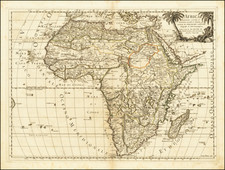
Fine Map of Africa with Distinctive, Decorative Border
Striking example of the 1732 edition of this ornate map of Africa, published by Guillaume Danet in Paris.
A defining feature of the map is the border, which is filled with dozens of maritime flags of states and polities. These include Malta, Tripoli, the Turks (Ottomans), and several insignia each for large countries like France and Britain. The flags are interspersed with delicate shells.
Interestingly, this example of the map is embellished with a number of orange circles and other marks. These are scattered throughout Africa and we have not identified a clear significance for their placement.
The map is centered on Africa, but also includes the Arabian Peninsula and part of Asia, much of southern Europe, and a large portion of South America. The Atlantic and Indian Oceans are filled with islands, many of which include notes about their date of encounter or their geography. For example, Ascension is described as “nothing more than a rock.”
Political units are separated by dotted lines. In Africa, these include Abyssinia, which houses the “Source du Nile.” Danet abandoned the Ptolemaic hypothesis for the source of the Nile in the Mountains of the Moon in South Africa, a representation that had frequented maps of previous centuries. Instead, he opted for a source of the Nile in eastern Africa, the location of the Blue Nile.
Rivers are of interest to Danet; they are the major geographic feature in the interior and they are often augmented with extra information. In the south, a note explains that the source of the Zambezi River is unknown, for example. There are also several large lakes in the African interior.
In central Africa, the kingdom of “Zendero ou Gengiro” is noted to be a powerful state. This is a reference to Janjero, also known as Yamma. The Hottentots, in reference to the Khoikhoi peoples of southern Africa, are described as wanderers and barbarous, the latter a reflection of European prejudices.
As the maritime flags of the border indicate, this map is made with trade in mind. Evidence of European commerce with Africa is written in the toponyms. For example, near the Cape of Good Hope is the “Fort Hollandois” in reference to the Dutch settlers who had established a Dutch East India Company colony there in 1652. In West Africa, in the Gulf of Guinea, is “La Mine.” Elmina was established in 1482; the castle was originally a trading factory; later, it was used to hold enslaved people bound for the Middle Passage and then plantations in the Americas. The castle survives today and is the oldest European building in existence south of the Sahara.
A lush cartouche is in the upper left corner, with a woman, likely representing Europe, showing a Black man, likely representing Africa, a necklace. He holds open shackles. At their feet are a cornucopia and a basket, as well as a snake, scorpion, shells, and gloves.
The meridian used in this map is calculated from the Isle de Fer in the Canary Islands. A note runs along the line explaining that Louis XIII fixed this meridian in 1634. This meridian was thought to be twenty degrees west of the Paris parallel. The choice of the more westerly meridian was supposed to standardize maps, but many cartographers continued to use other meridians as their primes.
This concern with the history and mechanics of cartography are also evident in a note in the bottom right corner. It explains that the projection used follows the work of a Mr. de la Hire. This is Philippe de la Hire, a notable French astronomer, mathematician, and painter. A member of the French Academy of Sciences and a fellow of a circle of savants that included Giovanni Domenico Cassini, Christiaan Huygens, Gottfried Liebniz, and René Descartes, de la Hire was interested in celestial movement, telescopes, and cartography. From 1679 to 1682, he made important measurements of the French coastline; in 1683 he calculated the extension of the Paris meridian to the north. Most of his writings were on graphical methods, hence his mention on this map.
The map was first issued by Danet in 1731 and later revised by Desnos in about 1760, at which time he significantly revised the cartographic details.
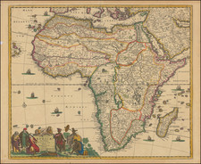
Monomotapa
In the southeast on this map are the “Etats du Manamotapa.” In the early fifteenth century, a prince of the Kingdom of Zimbabwe established his own seat of power called the Kingdom of Mutapa to the north. The kingdom expanded quickly, fed by the region’s gold reserves and trade connectivity.
The Portuguese heard of the empire, which reached its peak in 1480, when they rounded the Horn at the end of the fifteenth century and began trading along the coasts of southern Africa. The Portuguese traders transliterated the word for ruler, Mwenemutapa, to Monomotapa, which was then used to describe the region on maps.
In the 1560s, the Portuguese Crown entered into direct relations with Mutapa; in 1569, King Sebastian gave a coat arms to the Mwenemutapa, the first grant of arms to a native southern African. However, this interaction was not characteristic of Portuguese-Mutapa relations, which were often combative as the Portuguese sought to take over the local gold reserves. These gold reserves were connected in European minds to the gold mines of King Solomon, ensuring Monomotapa an enduring place in the European geographic imagination.
![[ World & Continents ] Typus Orbis Terrarum / Americae Sive Novi Orbis Nova Descriptio / Asiae Nova Descriptio / Africae Tabula Nova / Europae](https://storage.googleapis.com/raremaps/img/small/99250.jpg)