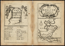
|
||

|

|
|

|
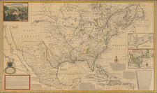
With Texas as a Republic.
Scarce map of North America, published shortly after Texas declared its independence from Mexico. This map also includes significant revisions in British Columbia attributable to the explorations and discoveries made by the Northwest Company and Hudson's Bay Company in the region.
The map is remarkably detailed, especially in the West. Texas is now named (the 1834 edition calls Texas "Santander"), with the "Free Indian" region in the north of Texas remaining on the map. Northwest of Texas, there is a significant amount of Indian and topographical details, more so than on most maps of the period. Oregon Territory includes the details from Lewis & Clark, the Astorians, and other early explorations in the region, along with lots of Indian details.
The map includes fine detail in Upper California, including the Missions, mythical rivers, notes on the Russian Settlements near San Francisco, and excellent detail north of the Gila River. Highly details NW Coast of America, including American, British and Russian settlements and forts, Indian Tribes, etc. Nice detail in Alaska, which is called "Polar Kreis." Massive Oregon and Missouri Territories are shown.
Weiland's maps are quite scarce, this being the first example we have handled of this 1841 edition. One of the most detailed western maps of the period. Not in Wheat.
![[Unusual Italian Immigrant Communities shown!] America Settentrionale, Centrale e Meridionale -- Carta Dimostrativa Delle Ambasciate, Legazioni, Consolati (Con Le Risettive Circoscrizioni Territoriali), Camere Di Commercio, Agenzie Commerciali, Stazion Enotecniche, Uffici Postali, Ospedali, Scuole Governative e Sussidiate All'Estero](https://storage.googleapis.com/raremaps/img/small/86098.jpg)
![Johnson's North America [with Inset of Hawaii]](https://storage.googleapis.com/raremaps/img/small/88883.jpg)
![Tabula Terre Nove [The Admiral's Map]](https://storage.googleapis.com/raremaps/img/small/81714.jpg)