


|
||

|

|
|

|
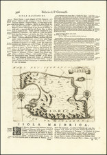
Very scarce miniature engraved chart of the town of Ibiza, on the Balearic Island of Ibiza.
This is possibly the first English printed chart of the famous Spanish port city of Ibiza, now so well known for its world-class nightlife.
The chart stretches from the Island of Fromenterra at the left (south) to Ibiza Town (Yvica) with its various streets and fort indicated. Nearby a town called "St. Hiliare" is also shown. The anchorage in the port is shown along with numerous soundings.
Maps of either the island or town of Ibiza are extremely rare. This is the first antiquarian map of the city that we have seen and handled.
Heather's The New Mediterranean Pilot
This small chart comes from the first English attempt at a collection of ports of the Mediterranean, although the genre was well established in France, Italy, and Spain already. The first was published by Joseph Roux in Marseilles in 1764, with versions published in several Italian port cities.
The French and Italian versions were of relatively crude execution, but Heather’s version is notable for the finely engraved charts, many signed in monogram by the London engraver John Stephenson.
![[Minorca] Plan de la Ville et du Port Mahon et du Fort Philippe Tel qu'il etoit Fortifie en 1706 par les Espagnols](https://storage.googleapis.com/raremaps/img/small/36450.jpg)
![Valetta, the Capital of the Island of Malta [with] Balearic Islands [and] Corsica and Sardinia](https://storage.googleapis.com/raremaps/img/small/87300.jpg)