This item has been sold, but you can enter your email address to be notified if another example becomes available.


|
||

|

|
|

|
Stock# 70757
Description
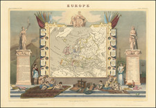
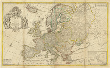
Rare English map of Europe, published in London by Robert Walton.
Walton's map shows all mainland Europe, extending northwards beyond North Cape to include Greenland, Nova Zemla, and Sir Hugh Willoughby's Land. This last place was named after the leader of an English expedition to find the north-east passage which ended in disaster, the participants starving to death on the Kola Peninsula in 1554.
The map includes the mythical the islands of Brazil and Frisland, in the north Atlantic.
Walton's map, unlike its Dutch counterparts, has a crude folk-art like quality, reflective of a period when English engravers were far less skilled than their Dutch counterparts.
Condition Description
Trimmed to the neatline with loss of carte-a-figures border, with margins extended for framing.
![[Ancient and Modern German Empires] Carte de la Germany et les Diferents Etats ou ses Peuples ont Porte Leurs Conquestes](https://storage.googleapis.com/raremaps/img/small/78195.jpg)