


|
||

|

|
|

|
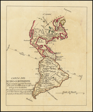
Large 18th Century English wall map of the Americas
Nice example of this fine four-sheet map of America, based upon the most recent information and with extensive annotations.This is the 1794 edition, with the change in date reflecting the inheritance of Robert Sayer's firm by his employees Laurie and Whittle.
Sayer and Bennett's map is one of the earliest obtainable English language wall maps of the Americas. It was periodically updated during the later part of the 18th century, first to include the information and boundaries established at the conclusion of the French and Indian War, and later, after the American Revolution and the establishment of the United States.
The map provides a stark contrast between the known and unknown regions, with the eastern parts of North America quite well understood, whereas the mythical River of the West is still shown, seeking a continuous watercourse from the Atlantic to the Pacific.
States
This example of the map includes a mix of two states, as is sometimes the case with Laurie and Whittle's wall map. The upper portion of the map is from a pre-1777 state, with the articles of peace that ended the French and Indian War noted. The lower portion of the map is from the 1794 state.
Robert Laurie (ca. 1755-1836) and James Whittle (1757-1818) formed their Fleet Street, London-based firm upon the 1794 death of their employer Robert Sayer, himself one of the dominant print and mapmakers of the last half of the 18th century.
Laurie & Whittle started managing Sayer's business as early as 1787. They took over all managerial duties when Sayer's health flagged in 1792, and they changed the imprint in 1794 upon his death. Sayer left the two a 21-year lease on the shop (at £100 a year) and on Sayer's Bolt Court premises, as well as an option to acquire stock and equipment at a preferential price of £5,000 payable over three years.
Robert Laurie retired from the firm in 1812, and his role was assumed by his son, Richard Holmes Laurie (1777-1858). The younger Laurie worked with James Whittle until the latter died in 1818. After R. H. Laurie died in 1858, Alexander George Findlay, FRGS (1812-1875) purchased the firm from his daughters. The firm continues today under another name, specializing in yachting charts.
Laurie & Whittle were prolific print and map publishers, and throughout their careers, they produced numerous very important and rare works. They carried on Robert Sayer's atlas business and were responsible for editions of The Complete East-India Pilot and The American Atlas.


![[Fruit Crate Label Advertising Map] Panama Brand (North America & Panama Canal)](https://storage.googleapis.com/raremaps/img/small/48860.jpg)