|
||

|

|
|

|
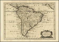
Rare Contemporary-Colored Example of Linschoten's Map of South America
Striking example of this spectacular map of South America, the Caribbean, Florida and the Gulf Coast, along with a marvelous treatment of the unknown southern continent.
Engraved by Arnold van Langren for Jan Huygen Linschoten's Itinerario, the map is richly-colored in a contemporary hand, making it a considerable rarity.
The map is west-oriented, showing the continent on a horizontal axis. To the right, or north, is Florida with over twenty toponyms included. The Caribbean stretches between the continents, with islands, sand bars, reefs, and shallows labeled. Mexico and Central America are also thick with toponyms denoting towns, lakes, and coastal features.
South America is split into Spanish viceroyalties and other administrative units—Peruvia (Peru), Chile, Castilia del Oro (Colombia), and a vast central region called Peruviana. To the east is Brasilia (Brazil), controlled by the Portuguese. There are large mountains ranges separating the Guyana region from the south, cutting east-west across Brazil, and cutting north south in the west.
The coastline is filled all the way around the continent with names of bays, ports, inlets, and coves. The interior, however, is filled with less practical features. In Brazil there are hyperbolic scenes of warfare and cannibalism. In the interior of the continent there are goats, a nursing dog-like animal, and a jaguar with a human face that lives on air alone, as is explained in a note nearby. Farther south, indigenous people converse and chase one of their fellows.
The toponyms in the Straits of Magellan come from that first circumnavigation, completed in 1519-1522. The southern shore of the Straits, Tierra del Fuego, is part of a vast southern continent. It is riddled with rivers that originate farther south and offers a tantalizing, if ultimately facetious, view of the then-unknown Antarctic region.
In the waters surrounding the continent are European ships sailing with aplomb; whales also spout. In the lower left corner is a scale bar in a cartouche frame. More elaborate cartouches of elaborate strapwork, cherubs, and floral decorations, are in the upper left and lower right corner. The one in the upper left carries the long-form title, along with the engraver’s name. In the lower right is a geographic overview of the map’s contents.
Linschoten, the Itinerario, and the van Langrens
This map was designed by Arnold Florent van Langren for one of his most famous clients, Jan Huyghen van Linschoten (1563-1611). As a young man, Linschoten traveled the world as part of the Portuguese East Indies trade. In 1583, his brother secured him a position as the Secretary to the Archbishop of Goa, a Portuguese colony. While abroad, he kept a diary, and began collecting other travelers’ diaries and accounts upon his return.
In 1594, Linschoten set out with Willem Barentsz on an exploratory expedition to find the Northeast Passage. The crew had many adventures, including an encounter with a polar bear, which they killed while attempting to capture it. Eventually, the crews had to turn back because of ice, a situation that also happened with a similar expedition the following year.
Upon his return, Linschoten published his journal from the Barenstz voyages. In 1595, he also published Reysgheschrift vande navigation der Portugaloysers in Orienten (Travel Accounts of Portuguese Navigation in the Orient) based on his research. The work includes sailing directions in addition to descriptions of lands still new to Europeans, like Japan. In 1597, Linschoten published again, this time a description of the African coast.
His most famous work, however, is Itinerario: Voyage ofte schipvaert van Jan Huyghen van Linschoten naer Oost ofte Portugaels Indien, 1579-1592 (Travel account of the voyage of the sailor Jan Huyghen van Linschoten to Portugese East India). It was published in 1596 by Cornelis Claesz in Amsterdam and then quickly translated into English (1598), German (1598), and French (1610). Latin editions appeared in Frankfurt in 1599 and Amsterdam in 1599.
Although Linschoten is known as the author of the Itinerario, he had a lot of help. Claesz convinced Linschoten to widen the project from his trip to Goa to include sailing directions and geographic descriptions, materials acquired from the Portuguese. The sailing directions proved important to the founding of the East India Company in 1602, as they revealed information previously kept clandestine by the Portuguese. Another person who played a role in the production of the book was Bernardus Paludanus, or Berent ten Broecke, who wrote the sections on Africa and America.
Claesz was also largely responsible for the addition of the maps. The first Amsterdam edition had a world map by Petrus Plancius, first published in 1594, and five detail maps, which were made by Arnold and his brother Henricus. The van Langren brothers were members of a prominent family of engravers. Along with their father, Jacob, the brothers also produced globes. The Van Langren family was granted a monopoly over globe production by the States General in 1592. In 1609, Arnold moved his family from Amsterdam to Antwerp, where his sons Jacob and Michael joined the business.
Rarity
While Linschoten's maps are not necessarily rare on the market, contemporary-color examples like this are extremely rare.