|
||

|

|
|

|
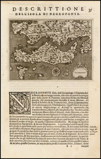
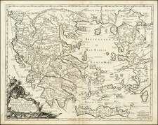
Nice full color example of Munster's map of Greece, from an early German edition of Munster's Cosmographia one of the most influential geographical works of the 16th Century.
Sebastian Munster's Geographia, first published in 1540 in Basle, is a significant work in the cartographic history of the early modern period. One of its standout pieces is the map of 'modern' Greece, an exquisite artifact that not only serves as a geographical guide but also as a portal into the socio-political tapestry of the mid-16th century Mediterranean world.
The coverage of the map extends from modern-day Greece up to the Danube River and includes the western part of Turkey and Asia Minor. This broad scope reflects the Hellenic influence that extended well beyond the borders of contemporary Greece.
Munster likely relied on the works of cartographers before him, particularly Sophianos, an eminent Greek scholar and cartographer whose own maps of Greece and the surrounding regions would have been the most comprehensive and accurate at that time.
Adrianapolis, or Edirne, was an important city in the region known as Thrace. It served as a significant military and political hub for the Ottoman Empire after its conquest in 1369, even functioning as its capital until the fall of Constantinople.
Nicopolis, founded by Augustus in 31 BC to commemorate his victory at the Battle of Actium, was an influential center in Roman Greece. Its ruins today lie near the modern city of Preveza.
Constantinople, modern Istanbul, was the capital of the Byzantine Empire, the Latin Empire, and the Ottoman Empire in succession, reflecting its key role in connecting Europe and Asia.
Pera (now known as Beyoğlu in Istanbul) and Chalcedon (present-day Kadıköy) were vital parts of Constantinople, embodying the city's diverse, cosmopolitan nature.
Byrsa was the heart of ancient Carthage, located in modern Tunisia. On Munster's map, it likely refers to Bursa, a city south of Istanbul and the first major capital of the Ottoman Empire.
Nicea (now Iznik), Callipolis (modern Gelibolu), and Troia (Troy) had crucial roles in the ancient world, serving as the sites of major battles and important historical events.
Mount Olympus in Greece was mythologized as the home of the Greek gods. Another Mount Olympus is marked near Byrsa (Bursa), potentially referring to the mountain in Mysia, an ancient region in Asia Minor.
Attica is the historical region encompassing Athens, the cradle of Western civilization. Athenae Satines (Athens) is known for its rich history, hosting landmarks like the Acropolis.
Corinthus (Corinth) was a wealthy city-state in classical Greece and a major player in various Greek wars. Modon (Methoni), Coron (Koroni), and Chania are coastal towns, once strategic locations for naval power and trade.
Ragusa (Dubrovnik), Suragzo (Zadar), and Velona (Venice) are Adriatic coastal cities. Their position on the map highlights the Adriatic Sea's prominence as a vital conduit for commerce and culture between the East and the West.
Munster's map of 'modern' Greece is thus more than just a geographical representation. Each landmark serves as a monument, encoding the rich historical saga of the Mediterranean region, from ancient city-states to medieval empires. A masterful synthesis of geography, history, and the art of map-making, it remains a timeless testament to human endeavor in understanding and mapping our world.
Sebastian Münster (1488-1552) was a cosmographer and professor of Hebrew who taught at Tübingen, Heidelberg, and Basel. He settled in the latter in 1529 and died there, of plague, in 1552. Münster made himself the center of a large network of scholars from whom he obtained geographic descriptions, maps, and directions.
As a young man, Münster joined the Franciscan order, in which he became a priest. He then studied geography at Tübingen, graduating in 1518. He moved to Basel, where he published a Hebrew grammar, one of the first books in Hebrew published in Germany. In 1521 Münster moved again, to Heidelberg, where he continued to publish Hebrew texts and the first German-produced books in Aramaic. After converting to Protestantism in 1529, he took over the chair of Hebrew at Basel, where he published his main Hebrew work, a two-volume Old Testament with a Latin translation.
Münster published his first known map, a map of Germany, in 1525. Three years later, he released a treatise on sundials. In 1540, he published Geographia universalis vetus et nova, an updated edition of Ptolemy’s Geographia. In addition to the Ptolemaic maps, Münster added 21 modern maps. One of Münster’s innovations was to include one map for each continent, a concept that would influence Ortelius and other early atlas makers. The Geographia was reprinted in 1542, 1545, and 1552.
He is best known for his Cosmographia universalis, first published in 1544 and released in at least 35 editions by 1628. It was the first German-language description of the world and contained 471 woodcuts and 26 maps over six volumes. Many of the maps were taken from the Geographia and modified over time. The Cosmographia was widely used in the sixteenth and seventeenth centuries. The text, woodcuts, and maps all influenced geographical thought for generations.
![[ Thessaloniki / Thermaic Gulf ] Die Landschaft Macedonien Nro. 17](https://storage.googleapis.com/raremaps/img/small/102208.jpg)