|
||

|

|
|

|
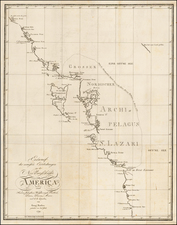
Extra-Illustrated Example of Cook's Map of the North Pacific – The Missing Piece of a Publishing Controversy!
Fine example of the map of the Northern Pacific and contiguous coasts of America and Asia, from the official account of Captain James Cook’s third voyage, published in London in 1784.
This example includes added cartographic information, drawn in a skilled hand, of western Baffin and Hudson’s Bays. It also shows the Coppermine River and the Canadian interior based on the overland expedition of Samuel Hearne in 1770-72. Together, they suggest that there is no easily-navigable waterway between the bays and the Pacific, negating the idea of an interior Northwest Passage.
The Hearne findings were the subject of considerable controversy in the preparation of this map; the base of this example is the map that was ultimately published along with the official voyage account. However, this annotated example is also related to a rival map published in the same year by William Faden, which was the first to include the Hearn expedition in print.
The Faden edition includes Hearn’s expedition almost precisely as it is drawn here. There are no narrative notes in this example, as there are in the Faden, and there are slightly fewer toponyms, which are also sometimes placed at different angles (example: Thleweyaza Yeth), as compared to the printed work. Near the Chesterfield Inlet, what is labeled as Baker’s Inlet on the Faden is labeled as Rankin’s Inlet on this example. The same inlet is not named on the official account edition. The Faden does not, however, include Baffin and Hudson’s Bays, making this example notable.
The annotations are professional in their precision and style, suggesting a trained draftsman as the artist. It is possible that this map was augmented to resemble the Faden. It is more probably, however, that this extra-illustrated example was used to prepare the plate from which Faden would print.
It is known that Lieutenant Henry Roberts, master’s mate and Cook’s chief cartographic assistant on the third voyage, had strong objections to changes suggested to the official account edition. He later sold his plate of the North Pacific to Faden, who then published it. This is likely an interim draft used to prepare the more detailed plate.
The map, on a curved projection, centers on the Bering Strait, showing how close Asia and North America are at high latitudes. Kamchatka is to the east, with a remarkable outline of Alaska to the west. The North American coast continues to the southeast, but the interior of North America is left empty.
For the first time on a printed map the coastline of Alaska and the northwest coast of North America are accurately portrayed. The map displays Cook and his crew’s great contribution to the mapping of the area, particularly along the coast of what is today Alaska (especially near Prince William Sound), in the Aleutians, and in the Bering Strait.
Cook's route in 1778, and Clerke’s route in 1779, after Cook’s death in Hawai’i, are shown in detail. As noted in the map's legend below the title, the map is also drawn in part from a Russian manuscript map. The Russians had explored the area during the Kamchatka Expeditions led by Vitus Bering (1725-30, 1733-43), and continued to sail along the northeast coast of Asia.
In addition, this example includes pen-and-ink annotations of the discoveries of Samuel Hearn in the Canadian Arctic. Hearn was the first European to make an overland trip via Canada to the Arctic Ocean (1770-1772). His observations were the first to show the outline of the coast in those areas, and he named the Coppermine River, included here. Hearn's journal and maps were not published until 1795; their portrayal here and in the Faden edition is based on a ca. 1772 manuscript map held by the Hudson’s Bay Company (HBC).
The pen-and-ink illustrations continue outside the border of the map, linking the printed Chesterfield Inlet to Hudson’s Bay and Baffin Bay. Hearn’s route is traced back to Fort Churchill and more details are added near Repulse Bay, which stem from the Middleton expedition (1741-2) in search of the Northwest Passage on behalf of the HBC. Joined together, the annotations suggest that an interior Northwest Passage linking bays to inlets to lakes and, eventually, to the Pacific was highly unlikely.
Cook’s third voyage
After two Pacific cruises that observed the Transit of Venus, charted New Zealand, the eastern coast of Australia, and many islands; and disproved the existence of a vast southern continent, Cook’s third voyage focused on searching for the Northwest Passage. It was also tasked with the return of Mai, a Ra’iatean man and the first Polynesian visitor to Britain, who had joined Cook’s second voyage.
Cook in the Resolution was joined by Charles Clerke in the Discovery. Resolution sailed in July from Plymouth, rounded the Cape of Good Hope, visited the Kerguelen group in the Southern Indian Ocean, then called at Tasmania before heading to New Zealand.
In the spring of 1777, the ships sailed north, first to Tonga, and then to Tahiti. They left Mai on Huahine, in a wooden house built for him by the crew. Cook continued north, and became the first European to encounter the Hawaiian Islands, in January 1778.
During the warm months (in the northern hemisphere) of 1778, Cook and his crew charted the northwestern coast of North America, calling at Nootka Sound and Prince William Sound. They went up the Cook Inlet, which they thought could be a Northwest Passage, but it proved to be a false start. Heading west, they skirted the Aleutians and sighted the Asian coast. In January 1779, they returned to Hawai’i to resupply and rest.
In Kealakekua Bay, Cook was greeted warmly by the Hawaiians. They stayed for three weeks, enjoying the considerable hospitality of the people. In early February, the ships set out for another northern tour, but only a few days from Hawai’i the Resolution’s mast was damaged, forcing their return.
This time, they were not welcomed by crowds. During a dispute over a stolen boat, a scuffle broke out. When it was over, sixteen Hawaiians, four marines, and Cook were dead.
Clerke took command. He forced the Hawaiians to give him Cook’s remains, which were buried at sea. He then led the ships north, passing through the Bering Strait before turning back due to ice. In August of 1779, Clerke too died, of consumption, while near Kamchatka. A third commander, John Gore, then had to lead the ships home.
The ships sighted Japan on their southward journey before calling at Macao. There, they made sizeable profits by selling sea otter pelts, kickstarting a new industry. By April 1780, the Resolution and Discovery were back at the Cape of Good Hope. They returned to Britain via the Orkneys, anchoring in the Thames on October 7, 1780.
Cartographic disputes over the North Pacific map of Cook’s third voyage
Cook's death left the production of the expedition's findings to two camps of editors. Henry Roberts and James King, the authors of the charts and journals and participants in the expedition, found themselves at constant odds with Alexander Dalrymple, Cook's longtime rival, Sir Joseph Banks, and Lord Keppel, among others. The production process was highly contentious. As noted by Hellen Wallis:
The maps and engravings were a major source of disagreement between the editors and the committee whose proceedings seem to have become more arbitrary with the succession of Keppel as First Lord. Banks and Webber [the voyage artist] supervised the engraving of the drawings while Alexander Dalrymple (none other) "at Lord Sandwich's desire," had direction of the charts and coastal views, with the exception of the general chart. Under the sole direction of the Admiralty this was being prepared by Lieutenant Henry Roberts, who had served as master's mate in the Resolution under William Bligh.
In a report by James King regarding a meeting he had with Sir Joseph Banks (King letter to Dr. John Douglas on July 25, 1782), King stated:
I was received coldly, perhaps owing to my having desired the engraver of the Genl. map not to proceed with it till further enquiry should be made whether the original plan of it should be altered in the way it was by Mr .Dalrymple . . . Sir Joseph then waited on Lord Keppel . . . the consequence was that his Lordship left the entire direction of the engraving of Mr. Webbers drawings as well as of the maps to him, upon which Sir Jos. summoned Mr. Roberts to lay before him the state of the Genl. map; desired him to give the drawings to him & told him that he had nothing further to do with it; as he should make what alterations in it he pleased, & be responsible for the propriety of those alterations & for its being engraved; Mr . Roberts finds himself very strangely treated by Sir Jos. & refused for the present complying with Sir Jos. request.
Upon finding that it was the declared intention of Sir Jos & Mr. Dalrymple to introduce tracts & alterations in this Genl. map which would rest upon Mr. Dalrymples authority only & that the motives for which, were to contradict some oppinions (sic) given by C. Cook, I begged Lord Duncannon would show Lord Keppel a few lines I wrote of the state of the publication, & that I took it for granted his Lordship would not authorise any alterations in maps without my being consulted. When I sent this to Lord Duncannon I did not know of the power that Lord Keppel had given Sir Jos. The answer I received was, that Lord Keppel could not recede from the promise he had given Sir Jos. When Mr. Roberts found that I was too insignificant to be consulted in these matters, he declared he would have nothing further to do with the map, as long as it was to be altered at the pleasure of those who had used him so ill, & who even told him, that it was not to be considered as a map of his drawing.
Dalrymple and Banks won out, and Roberts' chart was replaced with the less-detailed map engraved by T. Harmar (the same map that is the base of this example). As reported by King in a letter to the account’s editor, Dr John Douglas, on December 13, 1783:
The [Dalrymple] & Sir Jos. are determined to have their Polar map & not mine, & to have none of the Hudson bay Companies discoveries inserted saying that these things are only proper in the General Chart.
As noted by Helen Wallis:
This shows that the "Chart of the NW Coast of America and NE Coast of Asia" was the design of Dalrymple in collaboration with Banks, and explains the omission of any interior details of North America and of the name King George's Sound.
Roberts' "lost chart" contains a number of place names not found on the authorized version. The Roberts map published by Faden also includes important information which had never previously appeared in print, showing the Coppermine River (information probably suppressed for commercial reasons by the Hudson's Bay Company) and the impossibility of a Northwest Passage through Hudson's Bay to the Pacific Ocean. This example also includes this extra information and more in the form of the manuscript annotations.
It was not understood that Roberts' chart and the Faden were the same until 1985, when the British Library acquired a proof state of the map. Roberts had sold his copperplate to Faden, who published the "lost chart" a month after the publication of the official atlas. This annotated example adds another layer to this story by showing a preparatory draft of the more inclusive map, likely augmented by the disgruntled Roberts himself.
![[Collection of 10 manuscript charts and maps depicting the west coast of North America from Monterey, California, to just north of Salisbury Sound, Alaska.]](https://storage.googleapis.com/raremaps/img/small/98898.jpg)