


|
||

|

|
|

|
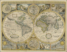
John Speed’s Acclaimed World Map
Excellent example of Speed’s celebrated double hemisphere world map, highly sought after for its rarity, extraordinary early geographic detail, and striking illustrative ornamentation.
It is one of the earliest obtainable world maps printed in England, as well as one of the earliest obtainable world maps printed in English. At the time of its original printing (1627), it was one of the first maps to depict California as an island and to show the settlement of New Plymouth in America.
The map itself is pleasingly embellished throughout with sea creatures and sailing vessels and encircled with a graticule along with climate zone inscriptions. The map is surrounded by smaller celestial hemispheres, figural representations of Water, Earth, Air, and Fire, and a number of celestial phenomena including solar and lunar eclipses. Portraits of the first circumnavigators are included at the corners of the map: Sir Francis Drake, Ferdinand Magellan, Thomas Cavendish and Olivier van Noort.
The influence of the contemporary Dutch cartographic tradition is clear on this map, evidenced by its decorative style combining portraiture and celestial illustration. Source maps used by Speed include Jodocus Hondius’ famed 1617 world map and William Grent’s rare 1625 world map.
Distributed throughout the map are numerous cartouches and annotations providing additional detail on the exploration of North America and the southern latitudes. The map title is included in a simple banner at top.
Along with California and Korea as islands, other fascinating mythical geographic details include a prominent northwestern coast of North America complete with conjectural place names, the vast Southern Continent or Magellanica, the Straits of Anian along with mention of the fabled Northwest Passage, the city of Manoa (El Dorado) accompanied by Lake Parime near Guiana, and the phantom island of Frisland off the coast of Greenland.
The unknown southern continent
Here, lands in the Antarctic are called the “Southerne Unknowne Land” and Magellanica, named after Ferdinand Magellan. In antiquity, Greco-Roman scholars and cosmographers such as Ptolemy posited that the Indian Ocean was enclosed by land, and that the continents of the globe should be balanced, in that the amount of land found in the Northern Hemisphere should exist in the Southern Hemisphere.
Ferdinand Magellan’s 1520 discovery of Tierra del Fuego was thought to support claims of a southern continent, and many prominent mapmakers, including Gerardus Mercator, strongly believed in the continent’s existence. This belief was eventually disproven by James Cook’s first (1768) and second (1772) voyages through the southern Pacific.
The place name Beach can be found at the tip of the southern continent in Southeast Asia, a toponym which first originated with a misreading of Marco Polo’s travel accounts. Marco Polo described the land as containing many riches, which explains the map’s annotation claiming the area to be abundant in spices. To the east of Beach, Mare Lantchidol is similarly an inaccurate transcription of the Malay-Javanese term ‘Laut Kidul’ (South Sea), which stems from Marco Polo’s accounts.
The cartouche placed on the southern continent notes that although the land is unknown, its existence has been proven by sailor’s accounts of its coasts. An annotation to the left of this cartouche explains Portuguese sailors have spotted Psittacorum Regio (“Country of Parrots”) in the area of the southern continent, and comments on the largeness of the birds recounted in the Portuguese sailor’s logs. Psittacorum Regio notably appeared on Gerard Mercator’s 1541 globe and his 1569 world map, leading to it becoming a common toponym on maps containing the southern continent.
On this map’s Magellanica, in the western hemisphere, a cartouche details English circumnavigation of the globe, discussing Sir Francis Drake and Thomas Cavendish. Another inscription credits the discovery of nearby coasts of Magellanica to Spanish sailors blown off course, probably a reference to the Loaisa expedition of 1525. The Loaisa expedition, meant to locate a missing ship from the Magellan expedition and also locate and colonize Magellan’s Spice Islands, encountered tremendous difficulties attempting to enter the Strait of Magellan. One of the ships in the expedition, the San Lesmes, captained by Francisco de Hoces, was blown southward and encountered land, possibly the earliest discovery of Cape Horn.
Exploration and conjecture in North America
The Straits of Anian refer to a mythical passage separating China and North America. The name Anian derives from Ania, a Chinese province on a large gulf mentioned in The Travels of Marco Polo. The gulf Polo described was actually the Gulf of Tonkin, but due to misreading the province’s description was transposed from Vietnam to areas much farther north. On this world map, a province named Anian can be seen at the far eastern edge of Asia, as well as in the passage between the continents. The first map to depict the Straits of Anian was Giacomo Gastaldi’s world map of 1562, followed by maps by Bolognino Zaltieri and Gerardus Mercator; thereafter it entered into widespread cartographic use.
The Straits of Anian was for many years considered to be the Pacific Ocean’s connection to the fabled Northwest Passage across North America. The Northwest Passage was long sought after by Europeans as an alternative route to the Far East. The first recorded exploration attempt was undertaken by John Cabot in 1497, but the general idea of a Northwest Passage originated in antiquity and was reprised by the fifteenth century revival of Ptolemaic maps.
Speculations about the passage appeared on maps until the nineteenth century, and numerous explorations were undertaken in search of a navigable sailing route. On this map, a substantial annotation in Canada details how English navigator John Davis found the Davis Strait separating North America and Greenland in pursuit of the Northwest Passage but was forced to turn back by ice.
In addition to John Davis, the voyages of Henry Hudson are prominent on this map. Next to the Davis Strait, Greenland can be seen vaguely connected to continental North America. Hudson’s Strait, Buttons Bay, and Hudson’s Bay are all clearly labeled. The annotation next to Hudson’s Bay refers to it as the “West Mediterranean Sea” found by Hudson.
The colonization of North America is also well documented on this map. It is one of the first to show the New Plymouth settlement and has New France, New England and Virginia clearly labeled. A cartouche in North America discusses Christopher Columbus and the naming of America after subsequent explorer Amerigo Vespucci.
El Dorado
In South America, the fabled Lake Parime and city of Manoa (El Dorado) are shown near Guiana. Manoa and Lake Parime (also known as Parima) were first identified by Sir Walter Raleigh in 1595 after he observed indigenous traders from the Manoa nation carrying gold and assumed they came from the mythical city of gold, El Dorado.
Lake Parime is thought to be a misunderstanding of indigenous accounts of annual flooding that caused the Amazon and Orinoco river systems to connect, forming a large body of water. This annual river flooding was used as a trading route by the Manoa nation and could have led to the misunderstanding that a city called Manoa existed on a large lake.
Early cartographic depictions of the western Pacific: Korea, Japan, and New Guinea
Korea is depicted as an island on this map. The Portuguese were the first Europeans to gain firsthand knowledge of East Asia in the sixteenth century, and Portuguese mapmaker Luis Teixera’s map of Japan with Korea as an island was a popular source of information on the geography of the region in the early seventeenth century. It is assumed that early European navigators in the region encountered the Yalu River, separating Korea from China, and thought it to be a strait between the Yellow Sea and Sea of Japan.
Japan appears as a large round island, further evidence of Luis Teixera’s influence. The islands of Southeast Asia are arrayed with relative accuracy for the time.
A spare sketch of New Guinea is included on this map, with “W. Schoutenland” labeled to the north. Willem Schouten completed a voyage to explore trading routes sailing west from the Netherlands to Asia in 1616 along with Jacob Le Maire. He is well known for naming the Le Maire Straits and Cape Horn and for discovering islands along the northern coast of New Guinea.
States of this map and rarity
The present example is the second state, with William Humble's imprint is located near the figure of Aire and the date advanced to 1651
The map is known to have four distinct states.
- The first state of this map is dated 1626, but it as published in 1627 as part of Speed’s atlas, A Prospect of the most Famous Parts of the World.
- The second state is dated 1651 and George Humble’s name has been replaced by his son’s, William Humble.
- The third state, issued by the Rea Brothers, bore their imprint and kept the date of 1651. Most of the Rea impressions perished in the Great Fire of London (1666).
- The plates for Speed's atlas were subsequently sold to Thomas Bassett and Richard Chiswell, who erased the Rea's imprint and added their own for fourth state in 1676. No further changes were made, so the date 1651 was preserved, visible at top right.
The present map is relatively scarce on the market. According to Rodney Shirley, the scarcity of the map can be explained by the fact that Speed's atlas did not enjoy the same level of popularity as its contemporary Dutch rivals. Most of the examples stayed within Great Britain.
The map is highly sought after by collectors today, making them relatively scarce on the market.
The Zeno Map and the mythical island of Frisland
The Zeno family was part of the Venetian elite; indeed, their family had controlled the monopoly over transport between Venice and the Holy Land during the Crusades. Nicolo Zeno set off in 1380 to England and Flanders; other evidence seems to corroborate this part of the voyage. Then, his ship was caught in a huge storm, blowing him off course and depositing him in the far North Atlantic. He and his crew were wrecked on a foreign shore, the island of Frislanda (sometimes Friesland or Freeland).
Thankfully, the shipwrecked Venetians were found by King of Frisland, Zichmni, who also ruled Porlanda, an island just south of Frisland. Zichmni was on a crusade to conquer his neighbors and Nicolo was happy to help him strategize. Nicolo wrote to his brother, Antonio, encouraging him to join him and, good navigator that he was, Antonio sailed for Frisland and arrived to help his brothers. Together, they led military campaigns against Zichmni’s enemies for fourteen years.
Their fights led the brothers to the surrounding islands, presumably enabling them to make their famous map. Zichmni attempted to take Islanda but was rebuffed. Instead, he took the small islands to the east, which are labeled on this map. Zichmni built a fort on one of the islands, Bres, and he gave command of this stronghold to Nicolo. The latter did not stay long, instead sailing to Greenland, where he came upon St. Thomas, a monastery in Greenland with central heating. Nicolo then returned to Frisland, where he died four years later, never to return to Venice.
Antonio, however, was still alive. He ran into a group of fishermen while on Frisland. These fishermen had been on a 25-year sojourn to Estotiland. Supposedly, Estotiland was a great civilization and Latin-speaking, while nearby Drogeo, to the south, was full of cannibals and beasts. Antonio, on Zichmni’s orders, sought these new lands, only to discover Icaria instead. The Icarians were not amenable to invasion, however, and Antonio led his men north to Engroneland, to the north. Zichmni was enthralled with this new place and explored inland. Antonio, however, returned to Frisland, abandoning the King. From there, Antonio sailed for his native Venice, where he died around 1403.
News of the discoveries and the first version of the Zeno map was published in 1558 by another Nicolo Zeno, a descendent of the navigator brothers. Nicolo the Younger published letters he had found in his family holdings, one from Nicolo to Antonio and another from Antonio to their other brother, Carlo, who served with distinction in the Venetian Navy. They were published under the title Dello Scoprimento dell’isole Frislanda, Eslanda, Engrouelanda, Estotilanda, & Icaria, fatto sotto il Polo Artico, da due Fratelli Zeni (On the Discovery of the Island of Frisland, Eslanda, Engroenland, Estotiland & Icaria, made by two Zen Brothers under the Arctic Pole) (Venice: Francesco Marcolini, 1558).
At the time of publication, the account attracted little to no suspicion; it was no more and no less fantastic than most other voyage and travel accounts of the time. Girolamo Ruscelli published a version of the Zeno map in 1561, only three years after it appeared in Zeno’s original work. Ruscelli was a Venetian publisher who also released an Italian translation of Ptolemy. Ruscelli had moved to Venice in 1549, where he became a prominent editor of travel writings and geography.
Ruscelli was not the only geographer to integrate the Zeno map into his work. Mercator used the map as a source for his 1569 world map and his later map of the North Pole. Ortelius used the Zeno islands in his map of the North Atlantic. Ramusio included them in his Delle Navigationo (1583), as did Hakluyt in his Divers Voyages (1582) and Principal Navigations (1600), and Purchas (with some reservation) in his Pilgrimes (1625). Frisland appeared on regional maps of the North Atlantic until the eighteenth century.
In the nineteenth century, when geography was popular as both a hobby and a scholarly discipline, the Zeno account and map came under scrutiny. Most famously, Frederick W. Lucas questioned the validity of the voyage in The Annals of the Voyages of the Brothers Nicolo and Antonio Zeno in the North Atlantic (1898). Lucas accused Nicolo the Younger of making the map up, using islands found on other maps and simply scattering them across the North Atlantic. He also accused Nicolo of trying to fabricate a Venetian claim to the New World that superseded the Genoan Columbus’ voyage. Other research has revealed that, when he was supposed to be fighting for Zichmni, Nicolo was in the service of Venice in Greece in the 1390s. He is known to have drafted a will in 1400 and died—in Venice, not Frisland—in 1402.
Scholars still enjoy trying to assign the Zeno islands to real geographic features. For example, Frisland is thought to be part of Iceland, while Esland is supposed to be the Shetlands. Some still believe the Zenos to have sailed to these lands. Most, however, view the voyage and the map as a reminder of the folly and fancy (and fun) of early travel literature and cartography. Whatever the truth, the Zeno map and its islands are one of the most enduring mysteries in the history of cartography.
The popular misconception of California as an island can be found on European maps from the sixteenth through the eighteenth centuries. From its first portrayal on a printed map by Diego Gutiérrez, in 1562, California was shown as part of North America by mapmakers, including Gerardus Mercator and Abraham Ortelius. In the 1620s, however, it began to appear as an island in several sources. While most of these show the equivalent of the modern state of California separated from the continent, others, like a manuscript chart by Joao Teixeira Albernaz I (ca. 1632) now in the collection of the National Library of Brasil shows the entire western half of North Americas as an island.
The myth of California as an island was most likely the result of the travel account of Sebastian Vizcaino, who had been sent north up the shore of California in 1602. A Carmelite friar, Fray Antonio de la Ascensión, accompanied him. Ascension described the land as an island and around 1620 sketched maps to that effect. Normally, this information would have been reviewed and locked in the Spanish repository, the Casa de la Contratación. However, the manuscript maps were intercepted in the Atlantic by the Dutch, who took them to Amsterdam where they began to circulate. Ascensión also published descriptions of the insular geography in Juan Torquemada’s Monarquia Indiana (1613) (with the island details curtailed somewhat) and in his own Relación breve of ca. 1620.
The first known maps to show California as an island were on the title pages of Antonio de Herrera’s Descripción de las Indias Occidentales (1622) and Jacob le Maire's Spieghel Der Australische Navigatie (1622). Two early examples of larger maps are those by Abraham Goos (1624) and another by Henry Briggs, which was included in Samuel Purchas’ Hakluytus Posthumus or Purchas his Pilgrimes (1625). In addition to Briggs and Goos, prominent practitioners like Jan Jansson and Nicolas Sanson adopted the new island and the practice became commonplace. John Speed’s map (1626-7), based on Briggs’ work, is well known for being one of the first to depict an insular California.
The island of California became a fixture on mid- and late-seventeenth century maps. The island suggested possible links to the Northwest Passage, with rivers in the North American interior supposedly connecting to the sea between California and the mainland. Furthermore, Francis Drake had landed in northern California on his circumnavigation (1577-80) and an insular California suggested that Spanish power in the area could be questioned.
Not everyone was convinced, however. Father Eusebio Kino, after extensive travels in what is now California, Arizona, and northern Mexico concluded that the island was actually a peninsula and published a map refuting the claim (Paris, 1705). Another skeptic was Guillaume De L’Isle. In 1700, De L’Isle discussed “whether California is an Island or a part of the continent” with J. D. Cassini; the letter was published in 1715. After reviewing all the literature available to him in Paris, De L’Isle concluded that the evidence supporting an insular California was not trustworthy. He also cited more recent explorations by the Jesuits (including Kino) that disproved the island theory. Later, in his map of 1722 (Carte d’Amerique dressee pour l’usage du Roy), De L’Isle would abandon the island theory entirely.
Despite Kino’s and De L’Isle’s work, California as an island remained common on maps until the mid-eighteenth century. De L’Isle’s son-in-law, Philippe Buache, for example, remained an adherent of the island depiction for some time. Another believer was Herman Moll, who reported that California was unequivocally an island, for he had had sailors in his offices that claimed to have circumnavigated it. In the face of such skepticism, the King of Spain, Ferdinand VII, had to issue a decree in 1747 proclaiming California to be a peninsula connected to North America; the geographic chimera, no matter how appealing, was not to be suffered any longer, although a few final maps were printed with the lingering island.
John Speed (1551 or '52 - 28 July 1629) was the best known English mapmaker of the Stuart period. Speed came to mapmaking late in life, producing his first maps in the 1590s and entering the trade in earnest when he was almost 60 years old.
John Speed's fame, which continues to this day, lies with two atlases, The Theatre of the Empire of Great Britaine (first published 1612), and the Prospect of the Most Famous Parts of the World (1627). While The Theatre ... started as solely a county atlas, it grew into an impressive world atlas with the inclusion of the Prospect in 1627. The plates for the atlas passed through many hands in the 17th century, and the book finally reached its apotheosis in 1676 when it was published by Thomas Bassett and Richard Chiswell, with a number of important maps added for the first time.


![Geografia sistematica d'Eratostene. [Geography of Eratosthenes]](https://storage.googleapis.com/raremaps/img/small/89132.jpg)