


|
||

|

|
|

|
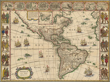
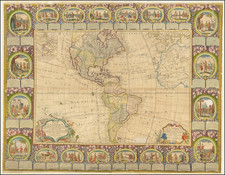
The Americas from the Master of the Golden Age of Dutch Cartography
Willem Blaeu's famous map of the Americas, one of the most sought-after maps of the continents from the Dutch Golden Age of Cartography.
The map blends contemporary geographical knowledge and rich decorative imagery. Blaeu's maps set the standard for the quality of the engraving, paper and color, as well as offered a fine compilation of contemporary geographical knowledge.
This map is a coveted example of Blaeu’s work; he made few maps relating to North America in particular. Goss states, “this magnificent map sums up the general European view of the western hemisphere in the early seventeenth century.”
This map illustrates excellent and intriguing detail throughout, including a rendition of the western coast of North America which did not follow the California as an island myth. There are dozens of place names along the eastern coast of North America, including Chesepeake (Chesepiooc), with French, English, Spanish, and Native toponyms and tribes.
The southern art of Hudson’s Bay is included on the main map, as is the tip of Greenland and the Davis Strait. John Davis led three expeditions north, in 1585, 1586, and 1587. He sailed along Greenland, Baffin Island, and Labrador, as well as charted the Davis Strait. He also found the entrance to Hudson Strait, which would be named for Henry Hudson thirty years later.
As a note mentions in the southernmost point of the Bay, Henry Hudson was in the area in 1611. Hudson was encouraged to explore for the Northwest Passage by none other than John Smith, who had sought an entrance to the passage via Chesapeake Bay. In the employ of the Dutch East India Company (VOC), Hudson set out in 1609. He first ventured up the Hudson River; while this was again no Northwest Passage, it did help the Dutch to colonize New York, or New Amsterdam as they called the settlement. In 1610, Hudson tried again, this time entering the eponymous Hudson Bay. His ship was trapped in the ice, his crew mutinied, and Hudson, his son, and seven others were set adrift in a small boat, never to be seen again.
In the far northern interior are two insets. The text box explains that the upper portions of the Davis Straits would not fit within the larger scheme of the map, hence its inclusion as a separate inset map showing Iceland, more of Greenland, and all of the Davis Strait.
South America includes several vignettes of Indigenous peoples. In Brazil there is a hut, a pair conversing, and a group hunting. There is also a cannibalism scene, which reflects the preoccupation of Europeans with the practice. Farther south, a European and a Native man speak; they are meant to illustrate the grand height of the so-called Patagonian giants. The first Europeans in southern South America, Ferdinand Magellan and his crews, supposedly saw giant footprints, which helped to name the region for Europeans and started a persistent myth about giants. Nearby, a four-legged creature walks determinedly.
Owing to a legal dispute between the Australian Company and the VOC, Blaeu was not allowed to include the Strait of Le Maire in his first state (1617). From the second state onward, however, the tip of South America ends in an insular Tierra del Fuego, which has a distinct star-shape. From that state, the map then also featured the Strait of Le Maire, which offered an alternative route to the Pacific than the Straits of Magellan. As the latter were ostensibly under the purview of the Dutch East India Company (VOC), Le Maire’s 1615-1617 voyage, with Willem Schouten, constituted one of the most important geographic discoveries of the seventeenth century. Interestingly, Blaeu also removed a speculative southern continent coastline between states one and two, but he left the place name Terra Australia Incognita on later states.
In the North Atlantic is a lonely island called Brasil. Hy Brasil is an enduring Atlantic chimera emerging from Celtic folklore. It ranges on maps from just off the west coast of Ireland to the area around the Azores. The island was initially described as a rich paradise not unlike Atlantis; it emerged from the depths for a short period and then would disappear. It started to appear on portolan charts in the fourteenth century and continued to be a stalwart of maps and charts into the nineteenth century. The island was the subject of a fanciful pamphlet by Richard Head in 1675. Despite no accurate reports of its whereabouts, the island appeared on Admiralty charts and other reputable maps for centuries, usually in the latitude of 51°N and at a longitude of 17°W.
Decorative embellishments
This map is as renowned for its decorative details as it is for its geography. Running along the top border are nine views of important Mexican and South American cities and harbors. These include Havana, Santo Domingo, Cartagena, Mexico City, Cusco, Potosi, Mocha Island (Chile), Rio de Janeiro, and Olinda (Pernambuco).
Drawn partially from the work of Theodor de Bry, on the two side borders are strips containing ten miniatures exhibiting the dress of Indigenous peoples from the Arctic to Patagonia. On the left are Greenlanders, Virginians, Floridians, New Albioners (Californians), and Mexicans. On the right are Peruvians, Brazilians, militant Brazilians, Mochans, and giants from the Strait of Magellan. Both the names used and the details featured, particularly weapons and scant clothing, emphasize ideas about Indigenous peoples that were popular with Europeans—they are more revealing of European thought than Indigenous reality.
A final detail are the eight large vessels in full sail. They represent the high volume of European commerce that criss-crossed the Atlantic, while those ships in the Pacific are more a hopeful call for increased trade than a reflection of the actual volume of European traffic in those waters. The ships should take care, though, as there are also four sea monsters surfacing around the map.
State of the Map
Blaeu first published continental maps as wall maps in 1608. In 1617, he began to release single-sheet continental maps, including this one.
The present map is an example of state 4. Burden identifies five states of the map as follows:
- State 1: No Le Maire Strait. Auct: Guiiljel: Janssonio in cartouche. (1617)
- State 2: New islands in the South Pacific. Le Maire Strait added. Tierra del Fuego now shown as an island. (1618)
- State 3: Name revised to Guiljelmo: Blaeuw (1621)
- State 4: New engraved areas in the sea, most notably in the square above the word "Capricorn" (Tropicus Capricorn), to the left of the sailing ship. (1642)
- State 5: Engraved areas extended in state 5 now have a rough cross-hatching and lack the wavy quality of earlier states. (1645)
Willem Janszoon Blaeu (1571-1638) was a prominent Dutch geographer and publisher. Born the son of a herring merchant, Blaeu chose not fish but mathematics and astronomy for his focus. He studied with the famous Danish astronomer Tycho Brahe, with whom he honed his instrument and globe making skills. Blaeu set up shop in Amsterdam, where he sold instruments and globes, published maps, and edited the works of intellectuals like Descartes and Hugo Grotius. In 1635, he released his atlas, Theatrum Orbis Terrarum, sive, Atlas novus.
Willem died in 1638. He had two sons, Cornelis (1610-1648) and Joan (1596-1673). Joan trained as a lawyer, but joined his father’s business rather than practice. After his father’s death, the brothers took over their father’s shop and Joan took on his work as hydrographer to the Dutch East India Company. Later in life, Joan would modify and greatly expand his father’s Atlas novus, eventually releasing his masterpiece, the Atlas maior, between 1662 and 1672.
![La America Dispuesta segun las ultimas y nuevas observationes de las Accademias, y de Paris, y de Londres [Bay or Sea of the West--Very Rare]](https://storage.googleapis.com/raremaps/img/small/75936.jpg)