|
||

|

|
|

|
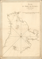
Very rare engraved chart o the Bay of Manilla and surrounding areas, published by Sayer & Bennett in London in 1778.
The chart depicts Manilla, as well as nearby villages and forts of Cavite, "el Paxian", Macati, Polvorista, Paravaque, Sta. Crux, Binondo, Jacubo, and Tondo.
The map extends north of Subec. Corregidor is called "Mariveles or Mirabella Island".
Rarity
The chart appeared as plate 69 in the 1778 edition of The Oriental pilot, or, A select collection of charts and plans... for the navigation of the country trade in the seas beyond the Cape of Good Hope.
The Oriental pilot was published for decades in shifting collations, with very few examples printed in each year. As such, the chartbook and its constituent charts are exceptionally rare. The last time this chart was on the market was in 1986.
Robert Sayer (ca. 1724-1794) was a prominent London map publisher. Robert’s father was a lawyer, but his older brother married Mary Overton, the widow of prominent mapmaker Philip Overton and the proprietor of his shop after his death. Mary continued the business for roughly a year after her marriage and then, in early 1748, it passed to Robert. Robert became a freeman of the Stationers’ Company later that year; his first advertisement as an independent publisher was released in December.
Sayer benefited from Overton’s considerable stock, which included the plates of John Senex. In the 1750s, Sayer specialized in design books and topographical prints, as well as comic mezzotints. In 1753, he, along with John Roque, published a new edition of Thomas Read’s Small British Atlas, the first of several county atlases that Sayer would publish.
Sayer’s business continued to grow. In 1760 he moved further down Fleet Street to larger premises at 53 Fleet Street. In 1766, he acquired Thomas Jefferys’ stock when the latter went bankrupt. In 1774, he entered into a partnership with John Bennett, his former apprentice. The pair specialized in American atlases, based on the work of Jefferys. They also began publishing navigational charts in the 1780s and quickly became the largest supplier of British charts in the trade.
Bennett’s mental health declined, and the partnership ended in 1784. As Sayer aged, he relied on his employees Robert Laurie and James Whittle, who eventually succeeded him. He spent more and more time at his house in Richmond. In 1794, he died in Bath.
John Bennett (fl. 1760-d. 1787) was a London printer best known for his role in the successful partnership of Sayer & Bennett. In 1760, Bennett became a servant of Robert Sayer (ca. 1724-1794), the prominent print and map seller, and was apprenticed to him in 1765. In 1774, Bennett became a free journeyman and entered into a partnership with Sayer. They issued joint advertisements and publications. In 1777, Bennett owned 1/3 share in the business. The partnership was likely to continue fruitfully, but in 1781 Bennett began to show signs of mental illness. In 1783, he was admitted to an asylum for nine months and, in 1784, Sayer filed papers to dissolve their business partnership. Bennett died in 1787.

![[English Edition!] Chinae, olim Sinarum regionis nova descriptio. auctore Ludouico Georgio.](https://storage.googleapis.com/raremaps/img/small/71123.jpg)