|
||

|

|
|

|
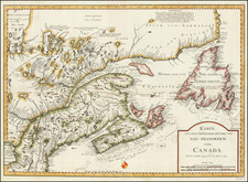
The Best Printed Survey of the St. Lawrence River to Date, with Only Two Other Examples Traced, and None in Canada
Rare wall chart of the Gulf of St. Lawrence and the River St. Lawrence, in six sheets, drawn by famed British colonial surveyor, astronomer and civil servant Thomas Wright.
Thomas Wright enjoyed a career of over half a century as a surveyor in North America, beginning in 1758. His assignments included serving as the official British astronomer to the commission to establish the boundary line between New Brunswick and Maine. As noted in greater detail in his biography below, Wright served as an Assistant to both Gerard De Brahm and Samuel Holland, Surveyor General of North America in the colonial period, and contributed to the creation of a number of important maps of Canada and New England. Wright served as Surveyor General of St. Johns Island from 1769 until his death in 1812. He also spent a significant amount of surveying the St. Lawrence and contiguous coastal regions. Wright would become perhaps the single most important surveyor of the region, privately publishing three charts: “A new Chart of the Gulf and River of Saint Lawrence to the Southern boundary of Lower Canada” (ca. 1785), “A New Chart of the Gulf of St. Lawrence” (1790), and “A New Geographical and Nautical Chart of the Gulf and River St. Lawrence” (1807).
This example of the latter chart was constructed by Wright in two primary sections. The principal section shows the entire extent of the River and Gulf of St. Lawrence from “Lac St. Francis” to Newfoundland. The second section is a larger-scale depiction of the river from the “Chaudiere River” to “Pt. Bonesir” and “Barnaby I.”
There are a series of detailed insets: “Minguan and Eskimo Islands Enlarged,” “York or Chateaux Bay,” “Old Ferolle Harbour,” an untitled chart of the coast from “Cape Raven” to “Griguet Bays” and “Canso Harbour.”
The bottom section of the chart provides some information on the Canada-District of the Maine border, with a border shown at the "Line due North from the Source of the St. Croix as decided by the Commissioners of 1798."
The map follows in the tradition of charting the St. Lawrence made famous among map collectors by the 1760 chart of James Cook, Samuel Holland, and Joseph Frederick Wallet Des Barres. Wright's work was an important improvement on the work of his predecessors, executed with a similarly meticulous study of the major artery for commerce and transit in British North America.
The chart served a dual purpose. First, it provided far greater detail in the critical region from Quebec and the Island Orleans to the area just beyond the Saguenay River where the St. Lawrence widens considerably as it nears the gulf. Second, it offered a much broader overview of the entire reach of the river, extending from the Ottawa River and Montreal to the Straits of Belle Isle. This overview includes an excellent indication of the navigable rivers feeding the St. Lawrence and the nearby coastal regions, expanding greatly on previous charts.
This, his third survey of the region, is the most important, and best, printed survey of the river to the date of publication.
Rarity
The chart is rare. We note only examples at the National Archives at Kew, the State Library of New South Wales, and an incomplete example (only five sheets) at Library and Archives Canada. Microfilm copies are located at BANQ and Université Laval.
No copy has appeared at auction since a 1978 sale in Montreal.
Thomas Wright was one of the foremost surveyors of the colonial period, serving across British North America. He was also an astronomer, judge, and a government official. Brought up in London, he studied at Christ’s Hospital, where he learned drawing and mathematics.
Wright ventured to North America for the first time in 1758. There, he continued his training as a surveyor, working with William Gerard de Brahm, then Surveyor General of Georgia. In 1763 he was appointed a deputy surveyor to Captain Samuel Holland, Surveyor General of the Northern District of North America. Wright was crucial to the surveys of St. John’s, Cape Breton, and the St. Lawrence River.
In 1767, Wright returned to England to ferry plans back to London. He sailed across the Atlantic again in 1769, having been assigned to observe the Transit of Venus from Quebec. He rejoined the survey of the Northern District, working with Holland in the Bay of Fundy and in New England.
Unlike many of Holland’s deputies, Wright was a civilian. He tried to secure a military commission, but was unsuccessful. Opportunity knocked when St. John’s Island was made a separate colony from neighboring Nova Scotia. Wright impressed incoming Governor Walter Patterson, who made Wright a member of the Council. An appointment as Surveyor General of the colony followed in 1773, although Wright continued to work with Holland as well. Due to the organization of landowners on St. John’s Island, meaning there was little Crown land to manage, Wright found himself with spare time to serve as a Supreme Court judge. His prominence meant that was taken prisoner at the beginning of the American Revolution, in 1775, when American privateers raided Charlottetown. He and a fellow official, Philipps Callbeck, were ordered to be released by General George Washington.
That same political prominence meant that Wright was also a target in colonial disputes. When St. John’s became a separate colony, it was supposed to support itself based on the collection of quitrents, or small annual fees paid by landowners. However, proprietors of the colony proved unwilling to pay, landing the colony in arrears. By 1781, Governor Patterson began to single out townships for their debts and selling them at auction.
These unpopular actions of Patterson’s harmed Wright’s career. He was suspended from both the Council and his position as Surveyor General in 1787. He was quickly reinstated, but the damage had been done. The landowners brought charges against Patterson and the Council; it was put before the British Privy Council in 1789. Wright defended himself at the trial and received a drubbing. He lost his Council position permanently but was allowed to maintain his role as Surveyor General due to the needs of his large family. Wright was not as active in local politics following the trial, although a Thomas Wright, either Wright himself or his son, served in the House of Assembly from 1797 to 1802.
Although several of Wright’s sons also worked as surveyors, the family still struggled. This was due in large part to the difficulties Wright had in obtaining his salary from the British Crown across his career. In St. John’s, his salary was to be paid by the quitrents, which were not reliably submitted. Once that system was abandoned, Wright complained that his salary had been unfairly reduced. The issue was not resolved until 1806.
Wright carried on with his work, however. He was a prominent member of the boundary commission established in 1796 to designate the border between the District of Maine and New Brunswick. As astronomer for the British delegation, Wright was returning to an area he had already surveyed over twenty years before. With his American counterpart, Wright took excellent observations, pinpointing the rivers in question. In the summer of 1797, Wright and Robert Pagan found the remains of early buildings built by Champlain and Du Gua de Monts in the early seventeenth century, proving which of the St. Croix Rivers was the original and which should therefore be used as the boundary.
He also published his findings. His Description of the island of Anticosti appeared in 1768. His correspondence with Astronomer Royal Nevil Maskelyne resulted in an article on the satellite of Jupiter, published in the Philosophical Transactions of the Royal Society in 1774.
Wright died in 1812 after fifty years of active service. He had surveyed from Georgia to the Maritime Provinces. While not as famous as Holland and Des Barres, he is still an important figure in the surveying of British North America, especially of the St. Lawrence River Basin. Two of Wright's sons and a grandson followed him as Surveyors General of St. John's Island, meaning a Wright for in the position for the first eighty years of the colony's existence.
![[ Maiune ]. Railroad & Township Map of the State of Maine with Portions of New Hampshire New Brunswick and Canada . . . 1855](https://storage.googleapis.com/raremaps/img/small/100890.jpg)