|
||

|

|
|

|
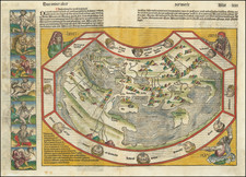
First edition of Munster's map of the World, one of the most recognized world maps of the 16th century.
This example is from the first woodblock (1540-1545), which can be distinguished from the editions of 1550 and after, the later editions being significantly revised and including the initials (DK) of the engraver David Kandel.
The map is based upon a mix of information derived from Verrazano's explorations (1522-24), which mistook the Chesapeake for the Pacific Ocean, and Cartier's voyages (1534-35) up the St. Lawrence in search of the Northwest Passage. The west coast of America appears on the right side of the map. This is also the 1st map to name the Pacific Ocean (Mare Pacificum). Munster is non-committal as to the continuity of North and South America, an unbroken Central America being implied but not clearly shown. Though unnamed, Terra Australis is present but small, only serving to form the Magellan Strait.
All of North America is called Terra Florida. Munster here adds further to the current confusion over Taprobana and Ceylon, depicting a Sumatra-shaped Taprobana on the west side of the Indian subcontinent, and Java in the approximately correct size and position of Sri Lanka.
Sebastian Münster (1488-1552) was a cosmographer and professor of Hebrew who taught at Tübingen, Heidelberg, and Basel. He settled in the latter in 1529 and died there, of plague, in 1552. Münster made himself the center of a large network of scholars from whom he obtained geographic descriptions, maps, and directions.
As a young man, Münster joined the Franciscan order, in which he became a priest. He then studied geography at Tübingen, graduating in 1518. He moved to Basel, where he published a Hebrew grammar, one of the first books in Hebrew published in Germany. In 1521 Münster moved again, to Heidelberg, where he continued to publish Hebrew texts and the first German-produced books in Aramaic. After converting to Protestantism in 1529, he took over the chair of Hebrew at Basel, where he published his main Hebrew work, a two-volume Old Testament with a Latin translation.
Münster published his first known map, a map of Germany, in 1525. Three years later, he released a treatise on sundials. In 1540, he published Geographia universalis vetus et nova, an updated edition of Ptolemy’s Geographia. In addition to the Ptolemaic maps, Münster added 21 modern maps. One of Münster’s innovations was to include one map for each continent, a concept that would influence Ortelius and other early atlas makers. The Geographia was reprinted in 1542, 1545, and 1552.
He is best known for his Cosmographia universalis, first published in 1544 and released in at least 35 editions by 1628. It was the first German-language description of the world and contained 471 woodcuts and 26 maps over six volumes. Many of the maps were taken from the Geographia and modified over time. The Cosmographia was widely used in the sixteenth and seventeenth centuries. The text, woodcuts, and maps all influenced geographical thought for generations.
![[World] Generale Ptholemei](https://storage.googleapis.com/raremaps/img/small/94338.jpg)