|
||

|

|
|

|
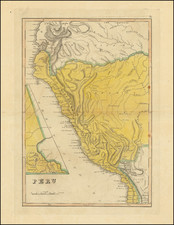
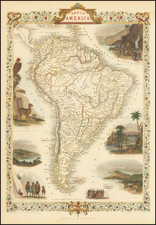
Striking Italian Map of South America
Rare 1766 edition of Paolo Petrini's South America, first published in Naples, ca. 1700.
This map, based on the work of Nicolas Sanson, shows the entirety of the continent, from Terra Ferma to Tierra del Fuego. The Mare del Nort (Atlantic Ocean) and the Mar del Sud (Pacific Ocean) give way near the littoral to the seas of Peru, Chile, Magellanico (Straits of Magellan), Paraguay, and Brasile.
Polities are separated by dotted lines, not to mention the formidable Andes Mountains. Besides the mountains, the main geographic features of note are the mighty rivers of Rio de la Plata and the Amazon. Both are shown with exaggerated width and with an emphasis on their tributaries which stretch far into the interior. Cities, towns, and missions are marked.
A quadruple scale bar is in the lower left corner, while a delicate cartouche adorns the lower right corner. This cartouche includes a dedication to the Prince of Avellino, a province in the south of Italy. It was the principal seat of the Caracciolo family, who were patrons of the arts.
Rarity
This map is quite scarce on the market. This is the first time we have offered the map in thirty years of trade.
One of the defining features of this and many maps of South America is a massive lake in the north, near Guiana. This is Lake Parime, a feature long-connected to the El Dorado myth. Rumors of a golden city in the New World were first tied to an initiation ceremony for a new chief of the Chibcha (Muisca) people. Bejewelled and covered in gold dust, the chief was supposedly ritually cleansed in sacred Lake Guatavita while more precious stones and metals were thrown into the water. El Dorado, as described by sixteenth and seventeenth-century chroniclers like Oviedo, Castellanos, and Freyle, was a reference to this “golden man.”
Quickly, the golden man was spun into stories of a golden city, which was supposed to perch on the shores of a vast lake. The precise location of both lake and city varied, however. Some searched in the Andes, others the interior. Gonzalo Pizarro set out east of the Incan Empire to find the city and instead lost nearly all of his 4,000 mean. One of his officers, Orellana, was ordered to continue the search and he eventually reached the Atlantic via the Amazon, the first European to do so.
Still others thought the lake and rich city must be near the Orinoco River. Expeditions in this area reached the ears of Sir Walter Raleigh, who led an expedition to Guiana in 1595. While his search failed, Raleigh sent another man, Lawrence Keymis, the next year. Keymis brought back word that a rich city, Manoa, did exist and that it was located on the shores of a Lake Parime. Raleigh published the information in his voyage account, thus popularizing Lake Parime as a geographic feature.
The lake appeared on maps from 1596 until the eighteenth century. The first was Jodocus Hondius’ Nieuwe Caerte van het Wonderbaer ende Goudrycke Landt Guiana. The lake is usually shown as a rectangular body of water on or near the Orinoco River as it approaches the equator. This quadrilateral of a lake is based on the interpretation of the body of water by Hessel Gerritsz in his 1625 Guiana sive Provinciae. While fewer and fewer maps featured the lake as the eighteenth-century wore on, the story was not disproven until the travels of Alexander von Humboldt in South America (1799-1804).