|
||

|

|
|

|
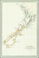
With Captain Edmund Bellairs Hand Written Annotations
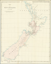
Fine example of the third edition of the so-called McDonnell-Wyld of New Zealand, published by James Wyld in London.
The present example includes the name Bellairs and the date 1849 and notes on the elevations of several of New Zealand's Mountains and a note stating " The finest mountain scenery in the world," describing Mt. Ruapehu. Additional pencil notes are found at the southernmost part of the map, where the owners seems to have been attempting to add in courses of several rivers further into the interior.
Bellairs is either Captain Edmund Bellairs or Eugene Bellairs. Captain Edmund was one of the early leaders in the efforts to place settlers in New Zealand in the early 1850s and a member of the Legislative Council. Edmund was the son of Sir William Bellairs (1793-1873), who was one of the founding members of the New Zealand Association. Eugene Bellairs was a contract surveyor employed by the New Zealand Company in the Nelson settlement. He was one of the surveyors involved in the incident in June, 1843 known as the “Wairau Massacre” from which he escaped unscathed. Subsequently he practiced in various parts of New Zealand for a number of years. He was licensed under the Native Land Act of 1865 by New Zealand Survey Board, vide New Zealand.
The annotations at the bottom of the map in pencil correspond with the area to which Edmund travelled in 1854 and acquired land in Waimahaka. While the Wairau massacre also occurred in this general vicinity, the chronology of Eugene's life suggests he was in New Zealand from the mid 1840s to 1862 and therefore less likely to have been the map's owner.
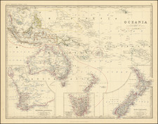
The map includes seven inset charts titled as follows: - Plan of the Entrance to Port Manouako - Plan of Victoria Bay of Islands - Port Nicholson - Oyerri or Pelorus River - Plan of Dusky Bay - Plan of Southern Port, Stewarts Island - Plan of the Bar and Part of the Hokianga River .
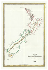
The McDonnell-Wyld map, first published in 1834, is one of the most important and influential early maps of New Zealand. Between 1834 and 1870, the map was issued in at least 27 different states, showing the evolution of New Zealand's early exploration and settlement. As a series, the maps graphically illustrate the vast changes between 1834 and the 1860s.
The map received excellent reviews in the New Zealand Journal (London). A review in the June 20, 1840 issue describes it as: "... the best general map of New Zealand extant." The review of the third edition in the November 12, 1840 issue notes "This edition is executed with Mr. Wyld's usual care. No pains have been spared to collect the best information, ... "
The chart was originally compiled by the early New Zealand trader Lieutenant Thomas McDonnell. After retiring from naval service in 1815, McDonnell spent some years in the service of the East India Company and in 1831, became a resident at Hokianga. J. O'C. Ross in his book This Stern Coast, notes that in 1834 McDonnell took his chart to England and persuaded James Wyld the Elder, to publish it. But as noted by Brian Hooker in his Note on the Original and Revised issues of the McDonnell-Wyld 1834 Chart of New Zealand:
there is no evidence to support either the idea that McDonnell compiled the chart in New Zealand or that he persuaded James Wyld to publish it. .. McDonnell compiled the chart some time after publication of Dumont d'Urville's 1833 atlas. McDonnell visited London early in 1834 and it seems more likely that he consulted d'Urville's atlas and other publications in London than at Hokianga.
John Tattersall in his booklet Lt. Thomas McDonnell and the Naming of Ahuriri points out that the pressure could have been the other way round and that McDonnell was pressed by Wyld to produce a chart. If McDonnell compiled the chart in London, as seems likely, then probably the idea for compiling the chart came from Wyld.
The only single-sheet general chart of New Zealand issued previous to 1834 was an unnumbered Admiralty chart published in 1816. There no doubt was a demand for a new general chart of New Zealand by 1834. But McDonnell's chart became more than just a new general chart; it served as the prototype for many charts subsequently published and influenced chart makers for fifteen years or more after it was first issued. McDonnell's influence was so strong that when the Hydrographic Office finally brought out a new general chart in 1838, they virtually published McDonnell's chart below the seal of the Hydrographer of the Navy.* * *
The printed date on the chart probably bears little relationship to the actual date of issue or printing. The original month and day of October 31 were changed to February 9 probably for the 1837 issue and changed again to February 19 for the 1852 and subsequent issues.
Some time after 1834, but before 1838, Wyld re-engraved parts of the copper plate and issued the chart with alterations and the added words: 'second edition'. The second edition example held by the Royal Geographical Society, London, is dated 9 February 1837 but whether any second edition charts were issued previous to 1837 is at present unknown.
In an article in the Map Collector P. L. Barton notes that the first known issue of the 'third' edition was published on 9 February 1840 and Wyld's name replaces McDonnell's in the title. (fn. 21) But the National Library of Australia, Canberra, holds a 'third edition' issue which pre-dates the issue referred to by Barton, and which closely resembles the 'second edition'. It still retains McDonnell's name in the title but has a little more additional data than the 'second edition'. Comparing the Turnbull 1840 issue with the Canberra 1840 issue it can be seen that a considerable amount of re-engraving of the copper plate was carried out before the 1840 Turnbull issue was printed. One explanation for the two 1840 issues of the chart is that Wyld preparing for his 'third edition' changed the word 'second' to 'third', '1839' to '1840' and then impatiently printed a few charts before continuing with the major alterations and additions to the copper plate.
. . . By early 1841 the copper plate had been re-engraved on five separate occasions and fresh impressions made, thus giving a total of six different states of the chart to this date. . . . . With considerable re-engraving being carried out during the seven years after the chart was first issued and fresh information constantly arriving from New Zealand it seems highly probable that the copper plate was revised and impressions made other than those listed 1 to 6 . . .
In the original chart four insets were included. With state 5 in 1840, the insets increased to seven. Some of the insets were updated. The Port Nicholson inset plan, for example, has a vague broken outline of a plan in state 5; by state 20 in 1860 it has a detailed plan. R. V. Tooley in his The Mapping of Australia (London, 1979), pages 172-173, lists some changes and additions in the different issues. At times the alterations were substantial; Tooley mentions that for the 1852 issue Stewart Island was redrawn.
. . . The Alexander Turnbull Library holds an issue dated 1865 and a print possibly issued in 1870.
Edmund Hooke Wilson Bellairs
Edmund Hook Wilson Bellairs (1823-96) was the eldest son of Sir William Bellairs, of Mulbarton Lodge, Norfolk.
Edmund entering the army (1841), he received his commission in the 60th Rifles and transferred to the 7th Fusiliers (1842) as a lieutenant. In 1848, he retired to accept the post of exon of the Yeomen of the Guard (1849), where he served until 1852.
In 1852, Bellairs married Emilia, daughter of James Bellairs Stevenson, of Uffington, and came to New Zealand in 1852. In 1854, he accompanied W. D. B. Mantell to the south to pay the Maori owners for the Murihiku block, acquiring land for himself at Waimahaka.
He was appointed a justice of the peace and in 1853 was part of the Legislative Council under the new constitution. He took a prominent part in the constitutional debates in 1854. Returning to England soon afterwards he vacated his seat on the Council.
In 1859, he acted as correspondent for The Times in Paris. Between 1861-64 he was captain and adjutant of the 1st Norfolk rifle volunteers. In 1878, he was appointed vice-consul at Bayonne (France) and in the following year transferred to Biarritz, where he lived for many years.
Bellairs died on September 14, 1896.
Eugene Bellairs
The son of the late Captain J. H. Bellairs, of the Royal Navy, he came to New Zealand early in 1843. Landing at Nelson, he joined one of the survey parties dispatched to survey the Wairau Plains on behalf of the New Zealand Company. Shortly after beginning operations, all the survey parties were turned off the land and their huts burnt to the ground, by order of the Maori chief Rauparaha. Mr. Bellairs subsequently joined the ill-fated expedition sent by the Government to apprehend the chiefs who were responsible for this act. The result was the so-called Wairau Massacre, where 22 members of the party were killed and Bellairs was only one of a few who survived.
He next went to Australia, where he was engaged in survey work. About 1862 Mr. Bellairs returned to New Zealand, and was engaged by the Government in making surveys, under the late Major Heaphy, during active operations in the Waikato.
James Wyld Sr. (1790-1836) was a British cartographer and one of Europe’s leading mapmakers. He made many contributions to cartography, including the introduction of lithography into map printing in 1812.
William Faden, another celebrated cartographer, passed down his mapmaking business to Wyld in 1823. The quality and quantity of Faden’s maps, combined with Wyld’s considerable skill, brought Wyld great prestige.
Wyld was named geographer to Kings George IV and William IV, as well as HRH the Duke of York. In 1825, he was elected an Associate of the Institution of Civil Engineers. He was one of the founding members of the Royal Geographical Society in 1830. Also in 1830, his son, James Wyld Jr., took over his publishing house. Wyld Sr. died of overwork on October 14, 1836.
James Wyld Jr. (1812-87) was a renowned cartographer in his own right and he successfully carried on his father’s business. He gained the title of Geographer to the Queen and H.R.H. Prince Albert. Punch (1850) described him in humorous cartographic terms, “If Mr. Wyld’s brain should be ever discovered (we will be bound he has a Map of it inside his hat), we should like to have a peep at it, for we have a suspicion that the two hemispheres must be printed, varnished, and glazed, exactly like a pair of globes.”