|
||

|

|
|

|
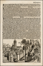
Striking, Large-Format Plan of Eighteenth-Century Vienna
Detailed, high resolution plan of the walled city of Vienna, with some of the new building projects in the Vorstädte shown as well.
At center is the old city, or Altstadt, with its surrounding bastions. Conspicuous within the city is St. Stephen’s Cathedral. A strip of green, undeveloped land separates the city center from the Vorstädte, or the suburbs. In the top left and right corners are tables explaining the different features of the city.
At bottom is a view of the city’s skyline. Another table running along the bottom of the plan explains the significance of each of the major buildings depicted.
Vienna in the eighteenth century
This plan shows Vienna as it was beginning to expand in the eighteenth century. In 1724, just before this plan was published, the population had reached 150,000; it had recovered and grown after devastating plague outbreaks in 1679 and 1713. By 1790, the population would balloon to 200,000.
The distinctive city walls surrounding the Altstadt were built to combat not disease, but invasion. After the First Turkish Siege of 1529, the previous city walls were found insufficient to stand up to sustained battery and a new building project commenced. The building of the new, more heavily-fortified walls lasted well into the seventeenth century. They proved their worth during the Second Turkish Siege of 1683, the last time the Ottoman Empire menaced Vienna.
Following the Second Turkish Siege, a spate of new building project began in the Vorstädte. These developments are visible on the edges of this plan. Outside the city walls, the nobility built up grand garden palaces known as Palais. These were surrounded by their own wall, the Linienwall, in 1704.
To the north of the city center is Leopoldstadt. This is where the city’s first factories were built in the eighteenth century. It also became the center of Jewish life in the city, as the community had been driven out of their former ghetto around 1720.
A fine snapshot of the geography and development of this important city.
Homann Heirs was a German publishing firm that enjoyed a major place in the European map market throughout the eighteenth century. Founded in 1702 by Johann Baptist Homann, the business passed to his son, Christoph, upon Johann’s death in 1724. Christoph died in 1730, aged only 27, and the firm was inherited by subsequent Homann heirs. This altered the name of the company, which was known as Homann Erben, or Homann heirs. The firm continued in business until 1848.
![[Holy Roman Empire] A Newe Mape of Germany Newly Augmented by Iohn Speed Ano Dom: 1626](https://storage.googleapis.com/raremaps/img/small/67323.jpg)