
This item has been sold, but you can enter your email address to be notified if another example becomes available.


|
||

|

|
|

|
Stock# 70473
Description
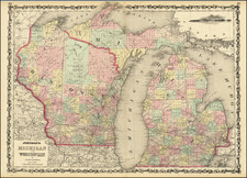
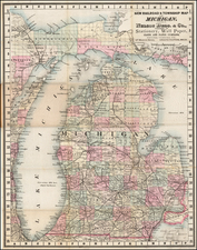
Remarkable large format map of Michigan, published by OW Gray.
Teh map is colored by counties, and shows towns, roads, rivers, lakes, mountains, forts, railroad lines, etc. The railroad lines with each station are identified.
One of the best large format atlas maps of the period.
Condition Description
Minor dampstaining in blank margin at left.

![[ Michigan ]](https://storage.googleapis.com/raremaps/img/small/99496.jpg)