|
||

|

|
|

|
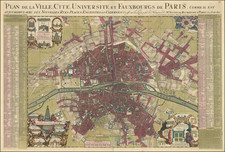
With Hand Drawn Boundaries Showing The Twenty Noble Departments of Paris Under The Reglements Royaux of April 13, 1789
Fine example of this detailed plan of Paris, published by Jean Lattre in 1777, redlined to show the 20 departments of Paris created for the electoral process of choosing Noble electors to the États-Généraux of 1789.
Includes an ornate cartouche and highly detailed plan, naming streets, buildings, churches, bridges, parks, and a host of other details.
The map has been augmented to show the division of Paris into 20 Departments, based upon a vote of the États-Généraux in 1789, the final time the the États-Généraux would meet prior to the creation of the revolutionary National Assembly in June 1789.
États-Généraux of 1789 was a general assembly representing the French estates of the realm: the clergy (First Estate), the nobility (Second Estate), and the commoners (Third Estate). It was the last of the Estates General of the Kingdom of France. Summoned by King Louis XVI, the Estates General of 1789 ended when the Third Estate became a National Assembly and, against the wishes of the King, invited the other two estates to join. This signaled the outbreak of the French Revolution.
For purposes of choosing electors, each estate divided Paris differently, with 10 electors for the clergy, 20 for nobility and 60 for the commoners.
The annotations to the map were almost certainly completed in the mid- to late-19th century, although there is the chance that it was prepared earlier, in connection with the preparations for the vote for Noble Electors.
Jean Lattré (fl. 1743-1793) was a Parisian bookseller and engraver who published many maps, plans, globes, and atlases. He worked closely with other important French cartographers, including Janvier, Bonne, and Delamarche, as well as other European mapmakers, such as William Faden, Santini, and Zannoni. Lattré is also interesting due to his propensity to bring suits against those who copied his work; plagiarism was common practice in eighteenth-century cartography and mapmakers struggled to maintain proprietary maps and information.
![[The Execution of Jean de Poltrot in Paris on March 18, 1563] Richtung des Meray Poltroc genant gescheen zu Paris den 18 Marzens 1563.](https://storage.googleapis.com/raremaps/img/small/78588.jpg)
![[ Saint-Denis ] Pourtraict de la Ville de Sainct Denis en France](https://storage.googleapis.com/raremaps/img/small/74991.jpg)