
This item has been sold, but you can enter your email address to be notified if another example becomes available.


|
||

|

|
|

|
Stock# 7046
Description
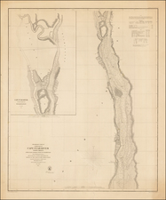
Scarce large format plan of Charleston Harbor, extending from the South Jetty to Drum Island. Shows a town plan of Charleston, Drum Island, Hogg Island, Shute's Folly Island, Moultrieville and Sullivan's Islands, Morris Island, James Island and Ft. Sumter, Ft. Johnson, Ft. Moutrie, Cummings Ft.Castle Pinkney, Ft. Riply, Beacon Bell etc. Includes Soundings, Beacons, Rivers, Jettys and many other details. From a scarce French Transportation work, published by the French Government.

![[ Florida Indians - Destroying the Enemy's Towns By Night ] Hostium oppida noctu incendendi ratio. XXXI.er absagen](https://storage.googleapis.com/raremaps/img/small/97385.jpg)
![[ Extensively Annotated By An Early Owner ] Georgia from the latest Authorities](https://storage.googleapis.com/raremaps/img/small/100877.jpg)
