|
||

|

|
|

|
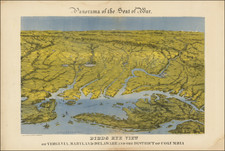
A Mathew Fontaine Maury - VMI - Rarity
Nice example of the extremely rare third edition of the so-called Bucholtz-Ludwig map of Virginia.
The Bucholtz-Ludwig map was originally based upon work done by Ludwig von Bucholtz, in connection with his updating of the Herman Boye map of Virginia in 1858. Bucholtz was hired to re-engrave the copperplates for the 4 and 9 sheet maps of Virginia originally made by Herman Boye in 1826. The ultimate products of his work were the very large (ca. 29 7/8" x 47", and ca. 62" x 93") maps of Virginia called the Boye-Bucholtz maps. As noted by Wooldridge:
Because Bucholtz had to work from Boye's existing 1826 copperplates, there was dissatisfaction even in 1859 with the Boye revision project. Francis H. Smith, Superintendent of Virginia Military Institute, wrote that the "bill appropriating $8000 under the plan of Mr. Bucholtz might as well direct so much money to be thrown into the James River."
According to E. M. Sanchez-Saavedra, "The knowledge Bucholtz gained on the revision project enabled him to produce several other state maps in the late 1850s. . . all of them geographically superior [to the Boye-Bucholtz map] because they were not superimposed upon incorrect copperplates." A Description of the Country, Virginia's Cartographers and Their Maps 1607-1881, p. 68 (Virginia State Library, Richmond 1975).
The first map in the sequence is Bucholtz's Map of the State of Virginia Containing the Counties, Principal Towns, Railroads Rivers, Canals & All Other/ internal Improvements Lithographed & Published by/ Ritchie & Dunnavant Richmond, Va. 1858 . . . prepared by L. Bucholtz Eng. by Ch. Ludwig. This map, which measured approximately 35.5 x 23.75, was vastly superior in detail and accuracy to Bucholtz's revison to the Herman Boye map. During the Civil War, the map was re-issued by West & Johnston in 1862 and 1864, under the title Map of the State of Virginia. Containing/ the Counties, Principal Towns, Railroads/ Rivers, Canals & All Other Internal Improvements Published by West & Johnston Richmond Va. As noted by Wooldridge:
There are minor geographic changes from Map 1 on Map 2. For example, on Map 2 Jerusalem in Southampton Co. has been moved a little to the northwest of its Map 1 location near the Seaboard and Roanoke Railroad, and the road between the two points imperfectly erased (the remaining shadow is additional evidence that the Map 1 stone was involved). Still, for the most part, Map 1 and Map 2 are the same map.
In 1868, the map was issued at under the direction of Matthew Fontaine Maury, under the title Virginia Military Institute Map of Virginia/ Compiled chiefly from C. L. Ludwig's Map and from other more recent data To accompany Preliminary Report of the Physical Survey of Virginia by M. F. Maury L.L.D. &c Prof. Physics V.M.I. Dec. 1868 Eng'd by C. L. Ludwig Richmond Va. As noted by Wooldridge:
The table of Rail Roads included on all the other maps . . . has been dropped, and a new title and imprint inserted . . . . The top 4 3/4 inches inside the neat line of maps 1 and 2, with the original large title and state seal, are cut off. The sliver of Pennsylvania between the Youghiogheny River in the West and Gettysburg in the East is completely blank, while the engraving extends through the country to the left and right of the blank area. . . .
Matthew Fontaine Maury offered it as "a map of the State less erroneous than any hitherto published." There are some changes from 1858. For example, it adds a projected Norfolk & Great Western Railroad through Southside Virginia. In Southampton Co., Jerusalem, located on Map 1 near the Seaboard and Roanoke Railroad and on Map 2 northwest of there, lies on Map 3 on the projected Norfolk & Great Western Railroad. Maps 1 and 2 measure longitude only from Washington while Maps 3 and 4 show degrees from Washington along the top border and degrees from Greenwich along the bottom.
In his article on the map, Wooldridge provides a marvelous discussion of the history of the Maury edition of the map, through excerpts from the Maury papers at the Library of Congress:
In 1868 General Francis H. Smith, Superintendent of the Virginia Military Institute, succeeded in persuading Matthew Fontaine Maury, the "Pathfinder of the Seas," who was then living in England, to return to Virginia to become professor of physics at VMI and to prepare a "physical survey of Virginia."
Smith had long been interested in creating, under VMI auspices, a better map of Virginia. Before the Civil War, he had written at length of his plan for "an accurate Geographical map based upon a careful triangulation of the State and such astronomical observations as would fix geographically the principal points in the primary triangulation."
Picking up after the War, Smith presented in the 1867 report of VMI's Board of Visitors an elaborate plan for the school to develop "a complete geographical and geological map" of Virginia as part of a work on "the entire physical geography of the state." Smith correctly predicted that the importance of this project would lure Maury back to Virginia.
Having accepted Smith's proposal, in the spring of 1868 Maury wrote Smith that the surveying parties would need instruments and suggested that he, Maury, obtain them while he was still in England. Maury recommended twelve pocket barometers, at $12 each, which would enable one to measure altitudes "as you ride about the country."
Maury sailed from England July 1, 1868. Smith busied himself assembling cartographic materials for Maury: 15 local maps of the Valley of Virginia, courtesy of General Robert E. Lee at neighboring Washington College, drafts of maps by Thomas H. Williamson, the professor of engineering and drawing at VMI, geological information from Col. [M.] McDo[nald, head of VMI's department of Minerology and Geology].
One offer of help came from farther afield. Marcus Ammen wrote from the Davenport Female College in Lenoir, Caldwell Co. NC, to solicit employment on the project as a "Topographist." He had done such work in the late war for General Beauregard, J.E.B. Stuart, Fitz Hugh Lee, Rosser, and others. He had spent eight months making a map of Fairfax Co. VA for Beauregard. Now he was a "Portrait and Landscape Painter by profession."
Stonewall Jackson's old mapmaker, Jedediah Hotchkiss, from Staunton volunteered to show Maury his maps of Augusta and other counties of the state.
Notwithstanding all the possible resources for a new map, there was not enough time (and probably not enough money) to carry out the process of surveying, triangulating, taking astronomical observations, and compiling a new map of Virginia as envisaged by General Smith. Maury would not have reached America until July 1868 and the first edition of the Preliminary Report for the physical survey went to the printer in December 1868. Some time in the fall of 1868 Smith and Maury must have decided to use the 1858 Bucholtz map (Map 1) with some changes. Bucholtz's engraver, Charles Ludwig, was still in business in Richmond and had access to the 1858 stone or some derivative stone.
While the rationale for adopting the old map does not seem to be spelled out in the Maury papers, the papers do show that Maury got his Virginia map from Ludwig. The title of the Maury map says "Compiled chiefly from C. L. Ludwig's Map, and from other more recent data," and separately credits Ludwig as engraver. Maury wrote General Smith from Richmond that "Ludwig has 1000 or more of his maps 1 & 2 worked off & yesterday I returned revise [sic - revisions?] to him." Maury sent the maps from Richmond to Baltimore for inclusion in the printed pamphlet . . .When he thought about a second edition, Maury wrote General Smith
The greatest delay will I apprehend be with Ludwig and the map of Virginia. Wherever you have the printing done, it is fair that he should have that map if he will multiply stones & bind himself to come up to time.
Two weeks later, Maury repeated to General Smith, "I do not think it would be quite fair to Ludwig to use in the next edition the present map of Virginia without his consent." Maury suggested paying Ludwig $100 for the use of it in the second edition. In the upshot, they used Ludwig's map only in the first edition (i.e., Map 3). The second edition (1869) had a new Virginia map by James H. Waddell.
A fourth edition of the map, entitled 4. Virginia Military Institute Map of Virginia And West Virginia 1858 . . . , was also issued, although Wooldridge in his article on the map notes that it is almost certain that this map was in fact published in 1869.
Rarity
The map is very rare on the market.
While Maury's Physical Survey of Virginia is not institutionally rare, no examples of the 1868 edition have been offered at auction in the past 30 years and no separate examples of the map have appeared at auction or in dealer catalogues during the same time period.
The following is excerpted from an advanced copy of an article written by William Wooldridge for The Portolan, entitled THE BUCHOLTZ – LUDWIG MAP OF VIRGINIA AND ITS SUCCESSORS, 1858-1868
Charles L. Ludwig was . . . . born about 1827 in Baden. . . As a young man he may have emigrated to the United States in 1850 or 1851. In 1856 he occupied the relatively lowly position of “clerk at Timmerman’s Variety Store, 81 Broad,” Richmond. In that year his future colleague in the lithography business, Lewis Hoyer, was proprietor of a jewelry shop on Main Street in Richmond.
In 1860 Ludwig was living in the household of his older business partner Lewis Hoyer. By then, both were listed as lithograhers. One would guess that either or both had learned the process in Germany but had not had the resources or connections to establish themselves in that business immediately upon their arrival in Richmond. Perhaps they were related. The household included, in addition to Hoyer and Hoyer’s wife and daughter, and Ludwig, eight young men aged from 18 to 27 listed as clerks. Probably the “clerks” were printers or apprentice printers in the establishment.
Hoyer & Ludwig did all kinds of printing before and during the Civil War: ballots, maps, Confederate stamps and bonds. They were, in the judgment of the Richmond Whig, “our most proficient lithographers.” From the internet, one can infer that the firm is better known to stamp collectors than to anyone else, and the considerable literature on Confederate philately might provide additional information on the principals.
Neither Ludwig von Bucholtz nor Lewis Hoyer have been noticed in business in Richmond after the end of the War. Charles Ludwig seems to have succeeded to the business of Hoyer & Ludwig. As already shown, he also controlled the lithographic stone, or some successor stone, for the 1858 Bucholtz-Ludwig map of Virginia, which he had engraved in the first place. By 1870, still listed as a lithographer, he valued his real estate at $40,000, an enormous sum in battle-scarred and burnt-over post-War Richmond. He even had an appointment as Swedish consol at Richmond for Virginia and North Carolina. . . .
Charles L. Ludwig of Richmond died at Hot Springs, Bath County, Virginia, July 23, 1875.
![[ Middle British Colonies Map ] Pensilvania Maryland and Virginia](https://storage.googleapis.com/raremaps/img/small/98228.jpg)
![[Amherst County Survey of 200 Acres Owned by Captain James Dillard dated 16, 1822]](https://storage.googleapis.com/raremaps/img/small/73745.jpg)
![Carte Particuliere de Virginie, Maryland, Pennsilvanie, La Nouvelle Jarsey. Orient et Occidentale [Heighten in Gold!]](https://storage.googleapis.com/raremaps/img/small/61392mp2.jpg)