


|
||

|

|
|

|
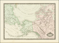
Map Illustrating the Maine-Canada boundary dispute, as ratified by the Webster-Ashburton Treaty of 1842
Rare Variant edition of the Webster-Ashburton Treaty Map, which includes a line below the title referencing James Wyld as the map engraver.
This fascinating map depicts the Canada-U.S. borderland from Lake Champlain to the Bay of Fundy, and shows the various boundary claims relating to the Maine-Canada boundary dispute, as well as the final agreement, pursuant the Webster-Ashburton Treaty of August 9, 1842.
The boundary dispute between the American state of the Maine and the British colonial provinces of New Brunswick and Lower Canada (Quebec) was one of the longest running and most acrimonious disagreements between the two nations. The origin of the dispute was found in the wording of the Treaty of Paris (1783), which concluded the American Revolutionary War and established the boundaries between the newly independent United States and what remained of British North America. The negotiators of the Treaty relied on outdated cartography, notably John Mitchell's A Map of the British and French Dominions in North America (1755), and so had a flawed understanding of the geography of the projected boundary, especially where it was to run through the interior.
The Treaty ordained that the northern section of the boundary between Maine and British territory was to run from where Quebec's boundary ended at the 45th parellel "along the height of land" to the St. John River. While the Maine-New Brunswick boundary had been resolved from Passamaquoddy Bay up northwards to near where the Aroostook River enters the St. John River, in 1797, the boundary beyond that further to the north remained in dispute. As shown on the present map, the British claimed that the "height of land" ran along the crest of the Appalachians (noted by a blue line), so claiming a large chunk of what Maine considered to be its territory. The Americans countered that the boundary should run along the height of land dividing the watersheds of the St. Lawrence River and the Gulf of Maine, so passing the border dangerously near the St. Lawrence River, Canada's lifeline. The American claim, if implemented, would also make it difficult for the British to build an all-season road between Quebec City and the St. John Valley, as at least half of the Upper St. John region had to be secured to provide a viable route. The disputed territory, amounting to almost 7,000 square miles is shaded pink on the map.
Unable to resolve the issue themselves, in 1831, the Americans and the British submitted their dueling claims to King Willem I of the Netherlands for non-binding arbitration. Willem duly proposed a compromise (the yellow line on the map), which the British rejected outright, as it heavily favored the Americans. The situation remained tense, with officials and lumberjacks from each side almost coming into armed conflict in 1838 and 1839, in what was exaggeratively known as the 'Aroostook War'.
The governments in both Washington and London were alarmed by the Aroostook incidents and mutually wanted to resolve the boundary dispute, once and for all, so as to avoid a diplomatic catastrophe sparked by hot-headed local residents. In 1842, U.S. Secretary of State Daniel Webster met with the British Minister to the U.S., Alexander Baring, 1st Baron Ashburton, to resolve the matter. Ashburton was under pressure to ensure that the British were granted enough of the Upper St. John so as to build the Quebec-New Brunswick road, while Webster had an embarrassing problem to resolve. The U.S. Army had recently constructed a massive brick fortress on the Richelieu River, Fort Montgomery, supposedly just south of the U.S.-Quebec line (the 45th parallel). However, recent surveys had shown that the 45th parallel and the international boundary actually ran to the south of the fort. Webster was determined to rescue what became known as "Fort Blunder", by having the U.S.-Quebec boundary moved north a touch, and in return he was prepared to concede more territory in Maine to the British, enough for them to comfortably build their road. Fortunately, in this Treaty both sides received what they really needed and both sides saved face.
In the immediate wake of the Treaty, 3 different London publishers came out with versions of the map depicting the boundary resolution, each with the same title. The most common of these was by John Wyld, issued with a pamphlet, George Featherstonhaugh's Observations upon the Treaty of Washington (1843), while another version was published by Her Majesty's Printing Office with the British government's official printing of the text of the treaty.
Present here, is by far the rarest of the editions, issued by M.S. Harrison & Co, St. Martin's Lane, Charing Cross. While most other examples of the Harrison version of the map show only the red line of the final Treaty boundary, this variant state features the shading of the region in dispute and the 3 colored propsed boundary lines, in addition to the final red line. The particular example includes its original title page and wrappers, but unusually it is unfolded, suggesting that it is perhaps the earliest of the three editions and possibly a proof state.
A rare and well-preserved artifact illustrating a seminal event of the history of New Brunswick and Maine.
James Wyld Sr. (1790-1836) was a British cartographer and one of Europe’s leading mapmakers. He made many contributions to cartography, including the introduction of lithography into map printing in 1812.
William Faden, another celebrated cartographer, passed down his mapmaking business to Wyld in 1823. The quality and quantity of Faden’s maps, combined with Wyld’s considerable skill, brought Wyld great prestige.
Wyld was named geographer to Kings George IV and William IV, as well as HRH the Duke of York. In 1825, he was elected an Associate of the Institution of Civil Engineers. He was one of the founding members of the Royal Geographical Society in 1830. Also in 1830, his son, James Wyld Jr., took over his publishing house. Wyld Sr. died of overwork on October 14, 1836.
James Wyld Jr. (1812-87) was a renowned cartographer in his own right and he successfully carried on his father’s business. He gained the title of Geographer to the Queen and H.R.H. Prince Albert. Punch (1850) described him in humorous cartographic terms, “If Mr. Wyld’s brain should be ever discovered (we will be bound he has a Map of it inside his hat), we should like to have a peep at it, for we have a suspicion that the two hemispheres must be printed, varnished, and glazed, exactly like a pair of globes.”
![[ Temperance Allegorical View ] Black Valley Railroad. Tickets Sold at all Liquor Shops. Accidents by Collisions are Entirely Avoided, as no up Trains are Run Over the Road.](https://storage.googleapis.com/raremaps/img/small/101469.jpg)
![[Unique Extra-Illustrated Example!] Carte Nouvelle Contenant La Partie d'Amerique La Plus Septentrionale, . . . Le Canada ou Nouvelle France, La Nouvelle Ecosse, La Nouvelle Angleterre, Les Nouveau Pais Bas, La Pensylvanie . . . Et Jle. de Terre Neuve . . .](https://storage.googleapis.com/raremaps/img/small/47720.jpg)