


|
||

|

|
|

|
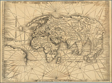
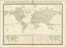
The First Map of the First Dutch Voyage to the East Indies in Spectacular Contemporary Hand-Color.
This is the first map of Cornelis de Houtman’s first voyage to the East Indies, the first such voyage by the Dutch. The map was suppressed when published and is consequently extraordinarily rare. This is only the fourth known copy. It is the only example in contemporary hand-color, the only separate example in private hands, and the only separate example outside of the Netherlands.
The map was made upon the return of the Houtman expedition to the East Indies, the first voyage by the Dutch to that region. It is the first printed map of this momentous event in global trade and world history.
While the focus of the map is on the waterways between Europe and Southeast Asia, the inland areas nevertheless include rivers and mountains, along with major settlements and tribal names. The seas include reefs and shoals which make the northwest Indian Ocean look quite perilous.
Of particular note is Terra Australis Incognita, a large landmass in the southeast. A section of the continent juts northward and has three toponyms: Lucach Regnum, Maletur Reg., and Beach Reg. These would be familiar to anyone who has read Marco Polo’s Travels. These three places were regions in Java. As can be seen, a Java Minor is nearby. This conflation of Java with the southern continent stemmed from an error. Initially, Polo used Arabic usage of Java Major for Java and Java Minor for Sumatra. After a printing mistake made Java Minor seem the largest island in the world in the 1532 edition of Polo’s Travels (Paris and Basel), mapmakers started to accommodate Java Minor, Beach, Lucach, and Maletur in a southern landmass.
A general chart, this map is intended to show the entire route of the four ships under the command of Cornelis van Houtman. The ships routes are included. The route to the East Indies has two sets of four ships; these are the Mauritius, Amsterdam, Hollandia, and Duifje. On the return route, two sets of three ships trudge toward the Netherlands. The crews burned the Amsterdam in Bawean in order to consolidate supplies and manpower.
Made for a maritime audience, but not for use onboard ship, the map has many decorative embellishments to delight a reader. In the upper right of the map is a set of three inset images of the inhabitants of the spice port of Bantam. In the lower right corner is another strapwork cartouche, this one with the map’s title in Latin and Dutch.
In the lower-left corner are two small insets. These are maps of Mossel Bay and the Bay d'Antongil on Madagascar. They are guarded by men in approximations of local dress. The four ships of the Dutch squadron are also shown at anchor.
Schilder suggests that this map was probably engraved by Benjamin Wright after the return of the Houtman voyage. Like the forbidden map of the East Indies, this general map of the entire expedition route was suppressed when first published. The merchants backing the initiation of Dutch trade in spices did not want the route and spice ports to be common knowledge until their access was assured.
Houtman’s voyage to the East Indies
Trade with the Indian subcontinent and the East Indies was becoming a central focus for the Dutch when this map was made. The Portuguese were the first Europeans to gain power in the East Indies, trading for spices in the Moluccas and controlling the spice market in Europe. The Dutch wanted in on the lucrative trade, but they also had to contend with the Portuguese.
The first step in establishing a trade was to gather information. Nine merchants sent Cornelis and Frederik de Houtman to Lisbon in 1592 to gather intelligence about the Portuguese spice trade. This had to be a clandestine trip, as the united Crowns of Portugal and Spain closed the Iberian Peninsula’s ports to Dutch ships in 1585 as part of the Eighty Years’ War. The brothers were not careful enough, as they were imprisoned for attempting to steal charts of the East Indies sailing route. Two years later, the Houtmans did manage to return north and they carried details about the route to the East Indies and the Portuguese presence there.
Their return coincided with that of Jan Huygen van Linschoten from India. Together their reports convinced merchants that the Dutch should attempt to start a trade at Bantam. The merchants founded the Compagnie van Verre and financed a fleet of four ships to sail to the East Indies. The ships were under the command of Cornelis and the brothers and their crews left Amsterdam on April 2, 1595.
Unfortunately, this was not to be an easy voyage. Insufficient provisions meant that scurvy struck the crews only a few weeks after setting out. The brief stopover in Madagascar turned into a mass funeral for seventy sailors. Aboard ship, numerous squabbles and disagreements broke out.
In June 1596, the ships arrived at Banten, a port in northwestern Java. They had passed through the Sunda Strait, not the Malacca Strait. The latter was under surveillance by the Portuguese and the Dutch ships did not want to risk a confrontation.
In Banten, Houtman met with the Sultan. The leader agreed upon a treaty with the Dutch. However, relations quickly soured due to Houtman’s lack of diplomacy. Instead, the ships tried to reach Madura but pirates attacked them en route. The ships limped into Madura and promptly attacked the people, who had received them peacefully, in retaliation for the acts of piracy. This proved rash; the pirates were not from Madura and the ships again had to sail on.
They next came ashore at Bali. Finally, they traded for a few peppercorns after meeting with the islands’ king. Later, at Bawean, the crews decided to burn the Amsterdam, one of the four ships, in order to consolidate their supplies and men. They turned back before ever reaching the actual Spice Islands, the Moluccas.
On their way home, the Portuguese prevented the ships from stopping at Saint Helena. 249 men had set out and only 87 returned. While the expedition was a disaster for most of the men involved, it provided an important victory for the Dutch. Houtman’s men did deliver some spices back to their merchant backers and they had made important initials contacts in Indonesia.
After Houtman, the second Dutch expedition (1598-1599) quickly set sail for the East Indies. It returned a 400% return for its investors. It quickly was followed by five others. In 1602, the most powerful of these merchants and the Dutch government, the States-General, created the Dutch East India Company (VOC), a monopoly to control the East Indies trade.
Cornelis died in battle against the forces of the Sultan of Aceh in 1599. Frederik was captured by the Sultan of Aceh when his brother was killed. While imprisoned, he studied the Malay language. Back in Amsterdam, he published the first Malay dictionary in 1603. He served as the governor of Amboina (Ambon) (1605-11) and the Moluccas (1621-23), an employee of the VOC. In 1619, he encountered shoals off the west coast of Australia which are named for him, the Houtman Abrolhos.
Rarity
This map was essentially unknown to historians of cartography in 1915, when Burger proposed the potential existence of a large Cornelis Claesz map covering the Houtman voyage. At the time no such map was known, but over the last sixty years knowledge of this map and several examples have emerged.
Schilder locates only three extant examples of the map, all in black and white, and all in the Netherlands.
This is the only known example in original color, the only in private hands, and the only outside of the Netherlands.
![[Elephants & Tourism] Chaine Des Elephants Plateau Du Bo'kor [Southeastern Cambodia]](https://storage.googleapis.com/raremaps/img/small/64472.jpg)