|
||

|

|
|

|
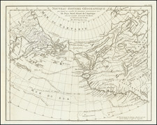
Stunning Old-Color Example of Willem Barentsz's Map of the Polar Regions
A landmark in Arctic cartography, the map is drawn from his observations during Barentsz’s third voyage (1596-7). Engraved by the van Doetecum family, this is a particularly fine example of the map in original color.
On this third voyage, Barentsz's ship was stuck in the ice, forcing him and his crew to winter on the northeast coast of Nova Zembla. According to the Osher Map Library, Barentsz drew the manuscript version of this map during the long, dark winter months.
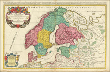
The map shows a sophisticated understanding of the Polar coasts of Europe as far east as Novaya Zemlya (often written as Nova Zembla and meaning "New World" in Russian), the furthest east that Barentsz reached. The mapping of the west coast of Novaya Zemlya is very comprehensive and features dozens of placenames. The spot where Barentsz and his men wintered is marked on this map with a small hut, made of ships’ timbers, and the label 'Het Behouden Huys,' or the safe house.
This is the first map to depict Spitsbergen, shown as Het Nieuwe Land north of Scandinavia. Barentsz discovered this far northern archipelago in 1596.
The coasts of Asia, further to the east, are speculative, with unfinished shores in Tartary. Here, reindeer pull a sleigh. Beyond this area is northernmost Asia, with some familiar place names like Mongul. At the edge of Eurasia lies the apocryphal Strait of Anian, supposedly the gateway from the Arctic to the Pacific Ocean. On the other side of the strait is Bergi Regio.
In the northern part of the strait is a curious-looking island. This is the Polus Magnetis, an island-like symbol meant to show the difference between the North Pole and the Magnetic North Pole. Navigators in this period well understood the effect of magnetic declination on their compasses and they had to accommodate for the variation when sailing.
In the west, Greenland and Iceland are well defined, along with the mythical island of Frisland (sometimes Friesland). To the south and west of Greenland are the straits and parts of Baffin Island recently discovered by Martin Frobisher and John Davis. Further north is the mythical Estotiland, which, like Frisland, originated from the apocryphal fourteenth-century Venetian voyage by the brothers Zeno.
One of the most notable features of the map are the many whales that dot the waters. Barentsz knew that his discoveries, especially Spitsbergen, would be a boon to the whaling industry. In addition, there are groups of seals, which were also hunted for their hides, meat, and fat. There is also a large ship near the Faroe Islands and several ships along the track of Barentsz’s voyage.
Three cartouches are arrayed around the map. Fine strapwork frames border the title in the upper center of the map, while the publishing information and scale bar are in the lower left.
The voyages of Willem Barentsz
During the early 1590s, the leading merchants of the Dutch Republic became very interested in opening trade routes with East Asia. Yet, they were deeply concerned that the established route to Asia, by way of the Cape of Good Hope and the Indian Ocean, was under the control of the Portuguese, who were enemies of the Dutch. Moreover, the established route was very long, and it was thought that any navigable polar route to Asia would be more expeditious.
While exploring the Northwest Passage via the North American Arctic was considered, the failure of Martin Frobisher and John Davis's various attempts to find such a route in the 1570s and 1580s discouraged any efforts in this direction. In 1553-54, the English adventurers Sir Hugh Willoughby and Richard Chancellor attempted to find a Northeast Passage to Asia, over Siberia, and while their mission ultimately failed in this regard, their progress and the nature of their reports convinced many in Amsterdam that such a passage could quite plausibly be opened, given another attempt. This torch was to be carried by Willem Barentsz.
Willem Barentsz (c. 1550-1597) was a Dutch map maker and explorer and one of the great pioneers of Arctic exploration. His first major work was an atlas of the Mediterranean, which he co-published with Petrus Plancius. Barentsz believed that the polar regions consisted of open waters above Siberia, due to the fact that they would be exposed to the sun 24 hours per day.
In the last decade of the sixteenth century, Barentsz made three voyages to the North Polar regions. In June 1594, Barentsz led an expedition of three ships which sailed from Texel for the Kara Sea. On this voyage, the crew made the first ever encounter with a polar bear. Barentsz's first voyage reached the west coast of Novaya Zemlya. After coasting northward, the crew encountered large icebergs and were forced to turn back and return to Holland.
In 1595, Prince Maurice of Orange commissioned a second expedition in two squadrons, with one commanded by Barentsz, which in total included six ships and a cargo of goods that were intended for trade with China. The expedition made several noteworthy encounters with Samoyed "wilde men" and polar bears, but was forced to turn back when they encountered a frozen Kara Sea.
In 1596, the Town Council of Amsterdam sponsored another voyage of two ships. They hoped to claim a reward offered by the Dutch States-General to the first expedition that navigated the Northeast Passage. Barentsz was a pilot on this voyage which discovered Spitsbergen before reaching Bear Island on July 1, 1596 and Novaya Zembla on July 17, 1596. Shortly thereafter, Barentsz's ship was stranded by ice and the sixteen-man crew was forced to winter there. After the spring thaw, the crew set out in two small boats on June 13; Barentsz died roughly seven days later. Seven weeks on, the remainder of the crew reached Kola and were rescued by a Russian merchant ship. The crew made it back to Amsterdam in November 1597 and several crew members wrote accounts of the voyage.
The wooden lodge where Barentsz's crew spent the winter was not revisited until 1871, when it was discovered by the Norwegian seal hunter Elling Carlsen. In 1875, Captain Gunderson returned to the site and collected several artifacts, including two maps and a handwritten translation of the Pet and Jackman voyages. In 1876, Charles L.W. Gardiner visited the site and collected many more artifacts and documents, including Barentsz's and Jacob van Heemskerck's notes on the settlement.
Publication of the map and rarity
The map is a well-balanced masterpiece of Late Mannerist Style. This is a testament to the fact that the publisher Cornelis Claesz commissioned the van Deutecum family, among the finest engravers and artists in the Low Countries, to design and engrave the map.
This map was originally published as a separately-issued map; several surviving examples can be found bound into composite atlases of the period. It featured in the 1599 Claesz Den Haag and the 1614 Walschaert Amsterdam editions of Linschoten's Itinerarium. After traveling in Iberia, India, and Africa, Jan Huyghen van Linschoten accompanied Barentsz on his first two voyages, so he had a vested personal and commercial interest in promoting his late friend's discoveries.
While Barentsz's attempts to find the Northeast Passage were ultimately not successful, his bravery and intellectual curiosity inspired future generations of polar explorers. This magnificent map serves as a foundation for all further Arctic exploration and mapping, especially in search of the Northeast Passage, making it one of the most important maps of its period.
Barentsz's map is much prized by collectors, although it is usually found uncolored and with significant condition issues. The present example is superlative, as it has magnificent contemporary color and is in a very fine condition. It is, by far, the finest example we have ever encountered.
This strait, believed to separate northwestern America from northeastern Asia, was related to the centuries-long quest to find a Northwest Passage connecting the Atlantic Ocean to the Pacific. The rumor of this strait and a Northwest Passage in general inspired many voyages of discovery, including those of John Cabot, Sir Francis Drake, Gaspar Corte-Real, Jacques Cartier, and Sir Humphrey Gilbert.
The term Anian itself comes from Marco Polo’s thirteenth-century accounts of his travels. Polo used the term to refer to the Gulf of Tonkin, but cartographers thought it could refer to this supposed strait between Asia and North America. The Strait of Anian, so named, first appeared in a 1562 map by Giacomo Gastaldi, and was later adopted by Bolognini Zaltieri and Gerard Mercator.
The Zeno Map and the mythical island of Frisland
The Zeno family was part of the Venetian elite; indeed, their family had controlled the monopoly over transport between Venice and the Holy Land during the Crusades. Nicolo Zeno set off in 1380 to England and Flanders; other evidence seems to corroborate this part of the voyage. Then, his ship was caught in a huge storm, blowing him off course and depositing him in the far North Atlantic. He and his crew were wrecked on a foreign shore, the island of Frislanda (sometimes Friesland or Freeland).
Thankfully, the shipwrecked Venetians were found by King of Frisland, Zichmni, who also ruled Porlanda, an island just south of Frisland. Zichmni was on a crusade to conquer his neighbors and Nicolo was happy to help him strategize. Nicolo wrote to his brother, Antonio, encouraging him to join him and, good navigator that he was, Antonio sailed for Frisland and arrived to help his brothers. Together, they led military campaigns against Zichmni’s enemies for fourteen years.
Their fights led the brothers to the surrounding islands, presumably enabling them to make their famous map. Zichmni attempted to take Islanda but was rebuffed. Instead, he took the small islands to the east, which are labeled on this map. Zichmni built a fort on one of the islands, Bres, and he gave command of this stronghold to Nicolo. The latter did not stay long, instead sailing to Greenland, where he came upon St. Thomas, a monastery in Greenland with central heating. Nicolo then returned to Frisland, where he died four years later, never to return to Venice.
Antonio, however, was still alive. He ran into a group of fishermen while on Frisland. These fishermen had been on a 25-year sojourn to Estotiland. Supposedly, Estotiland was a great civilization and Latin-speaking, while nearby Drogeo, to the south, was full of cannibals and beasts. Antonio, on Zichmni’s orders, sought these new lands, only to discover Icaria instead. The Icarians were not amenable to invasion, however, and Antonio led his men north to Engroneland, to the north. Zichmni was enthralled with this new place and explored inland. Antonio, however, returned to Frisland, abandoning the King. From there, Antonio sailed for his native Venice, where he died around 1403.
News of the discoveries and the first version of the Zeno map was published in 1558 by another Nicolo Zeno, a descendent of the navigator brothers. Nicolo the Younger published letters he had found in his family holdings, one from Nicolo to Antonio and another from Antonio to their other brother, Carlo, who served with distinction in the Venetian Navy. They were published under the title Dello Scoprimento dell’isole Frislanda, Eslanda, Engrouelanda, Estotilanda, & Icaria, fatto sotto il Polo Artico, da due Fratelli Zeni (On the Discovery of the Island of Frisland, Eslanda, Engroenland, Estotiland & Icaria, made by two Zen Brothers under the Arctic Pole) (Venice: Francesco Marcolini, 1558).
At the time of publication, the account attracted little to no suspicion; it was no more and no less fantastic than most other voyage and travel accounts of the time. Girolamo Ruscelli published a version of the Zeno map in 1561, only three years after it appeared in Zeno’s original work. Ruscelli was a Venetian publisher who also released an Italian translation of Ptolemy. Ruscelli had moved to Venice in 1549, where he became a prominent editor of travel writings and geography.
Ruscelli was not the only geographer to integrate the Zeno map into his work. Mercator used the map as a source for his 1569 world map and his later map of the North Pole. Ortelius used the Zeno islands in his map of the North Atlantic. Ramusio included them in his Delle Navigationo (1583), as did Hakluyt in his Divers Voyages (1582) and Principal Navigations (1600), and Purchas (with some reservation) in his Pilgrimes (1625). Frisland appeared on regional maps of the North Atlantic until the eighteenth century.
In the nineteenth century, when geography was popular as both a hobby and a scholarly discipline, the Zeno account and map came under scrutiny. Most famously, Frederick W. Lucas questioned the validity of the voyage in The Annals of the Voyages of the Brothers Nicolo and Antonio Zeno in the North Atlantic (1898). Lucas accused Nicolo the Younger of making the map up, using islands found on other maps and simply scattering them across the North Atlantic. He also accused Nicolo of trying to fabricate a Venetian claim to the New World that superseded the Genoan Columbus’ voyage. Other research has revealed that, when he was supposed to be fighting for Zichmni, Nicolo was in the service of Venice in Greece in the 1390s. He is known to have drafted a will in 1400 and died—in Venice, not Frisland—in 1402.
Scholars still enjoy trying to assign the Zeno islands to real geographic features. For example, Frisland is thought to be part of Iceland, while Esland is supposed to be the Shetlands. Some still believe the Zenos to have sailed to these lands. Most, however, view the voyage and the map as a reminder of the folly and fancy (and fun) of early travel literature and cartography. Whatever the truth, the Zeno map and its islands are one of the most enduring mysteries in the history of cartography.