


|
||

|

|
|

|
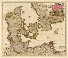
The Most Important Domestically Published Map of Sweden in the 18th Century
Highly detailed map of Sweden and Finland, by leading Swedish mapmaker Georg Biurman.
A nice example of this landmark map, which saw the rebirth of domestic map publication in Sweden, which had lay dormant from the early 17th Century map by Buerus in 1626. The map was a product of the Kingdom's newly found interest in domestic mapmaking, following the conclusion of the Russo-Swedish War of 1741-43. A civilian mapping commission was sent to Finland to produce manuscript maps of all of its parishes on a uniform scale of 1:20,000.
Biurman's map includes topographical details, towns, rivers, islands and other important features. The map includes a large inset of the upper portion of Sweden.
As noted by the Volume 4 of the History of Cartography at pp 555-57,
In 1747, Biurman published the first domestically produced accurate map of Sweden-Finland since Bureus [in 1626]. The map was not large, but included enough details to surpass every earlier map [and would become the model for European mapmakers during the second half of the 18th Century.]
Georg Biurman (1700-1755), was a Swedish surveyor and engraver at the old land survey office in Stockholm. He became known for a wide range of detailed mapping over Stockholm and Sweden as well as a travel guide that was published in 1742. In the 1730s, Biurman became the head of the printing company that was established at the land survey at Västra Trädgårdsgatan 2 in Stockholm.
Rarity
OCLC locates a single example in an American institutional collection (Harvard), along with copies in several other National Libraries and European collections.
We note 1 example in a dealer catalog in the past 40 years (PAMA, 2003) and no copies at auction.
Georg Biurman was a Swedish surveyor and engraver in Stockholm.
Biurman is best known for a his series of separately published maps of Stockholm and Sweden, as well as a travel guide that was published in 1742.
In the 1730s, Biurman became head of the printing house that was established at the surveyor at Västra Trädgårdsgatan 2 in Stockholm.
Biurman's travel guide received its privilege to published his travel guide in 1742, which was the first official travel guide following the guide published by Peter Warnmarck in 1709. Biurman's book was published in four supplemented editions, the last in 1776. The guide contains two maps, which include accurate information about roads, inns, cities and other towns and distances from Stockholm and between towns along the main roads throughout the country.
Biurman produced a map of Sweden including Finland, several landscape maps, several maps of Stockholm , including one with the city's surroundings, a Kungsholm map and a Mälaren map.

![[ Nyköpings Chiefdom / Southwestern Sweden ] Charta öfver Nyköpings Höfdingedöme. Utgivfven Af Firherre S. G. Hermelin. Författad af CP Hällström, Premiär Ingeniör, 1804](https://storage.googleapis.com/raremaps/img/small/99082.jpg)