![Africa / Lybia / Morland / mit allen kunigsreichen so zu unsern zeiten darin gefunden werden [Afrika/Libyen/Morenland, with all the kingdoms found therein in our time] By Sebastian Munster](https://storage.googleapis.com/raremaps/img/small/95771.jpg)


|
||

|

|
|

|
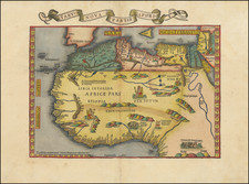
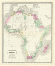
Earliest map of the Continent of Africa, with curious river routes.
Early edition of Münster's map of Africa. The map appeared in Cosmographia universalis (1544-1628), as well as in Munster's other famous work, his version of Ptolemy's Geographia (1540-52).
Münster was the first mapmaker to show each of the four known continents on their own plates and his map of Africa is widely accepted as the first map of the entire, navigable African continent. The map is based in part upon Ptolemy, but also includes modern Portuguese and Arabic information.
The coastal outline of Africa had only recently been understood by Europeans. Bartolomeo Dias had only rounded the Cape of Good Hope in 1488, while Vasco de Gama reached India by sea a decade later. The cartouche in the lower left details sailing directions from Lusitania (Iberian Peninsula) to Calcutta. The Portuguese caravel in the Gulf of Guinea represents trade and navigation.
The map is richly illustrated with vignettes, including an elephant and tropical birds in southern Africa. In what is today Nigeria and Cameroon, there is a Cyclops or one-eyed man, a reference to the fabled tribe of the Monoculi. The map depicts numerous kingdoms, marked by a scepter within a crown. Finally, towns and cities dot the continent, mostly along the northern coast and Nile River. They include Meroë, where the Nubian kings are said to be buried, and Prester John's fabled settlement.
Münster also speculates as to the sources for the Niger and Nile Rivers, as well as places a curious forest in the middle of the Sahara Desert. A desert forest isn't the most interesting geographic feature on the map, however. As John Delaney points out, "One of the intriguing aspects of this map is the loop of the Senegal River, which is shown entering the ocean in today's Gulf of Guinea. Actually, this is the true route of the Niger River, but that fact will not be confirmed until the Lander brothers' expedition in 1830. Strangely, this loop disappeared from subsequent maps of Africa for the next two hundred years."
Sebastian Münster (1489-1552) was a professor of Hebrew who taught at Heidelberg and Basel. He settled in the latter in 1529 and died there, of plague, in 1552. Münster made himself the center of a large network of scholars from whom he obtained geographic descriptions, maps, and directions. He is best known for his Cosmographia universalis, first published in 1544 and released in forty editions by 1628.
![[ Shows Negroland ] Africa, Drawn and Engraved from the best Maps and Charts](https://storage.googleapis.com/raremaps/img/small/95133.jpg)