|
||

|

|
|

|
Stock# 70220
Description
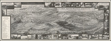
Antique printed color map of New York State, published in Asher & Adams' New Topographical Atlas and Gazetteer of New York.
The map shows the average mean temperature for the year bu isothermal lines (red) and the mean average rainfall in inches (shaded boxes).
Condition Description
Minor offsetting.
Asher & Adams Biography
Asher & Adams was a New York publishing firm known for their atlases. Notably, their maps were some of the first to prominently exhibit railroad lines, even if this meant a slight reduction in topographical detail. They specialized especially in state and county maps of the United States.
![[Pennsylvania, New Jersey, New York ] Speciel Land Charte von Pensilvanien, Neu Jersey, Neu York und von denen drey Land-schafften an dem Delaware Fl. In America in Englischer Spr. gedruckt A. 1749 In Europa duffgelegt in Teutsch Spr. zu Francfurt am M. A. 1750.](https://storage.googleapis.com/raremaps/img/small/51958.jpg)