


|
||

|

|
|

|
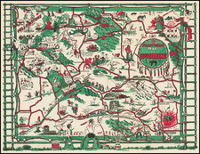
Fine birdseye view style map of Lake Winnipesaukee, published by George Walker & Co, for the Boston & Maine Railroad.
The map provides a striking view of the Lake, with major islands, bays and other features named. The key at the bottom of the view locates 85 points of interest.
On the verso, there are a number of photos and promotional text describing the lake and its recreational choices. Many New Hampshire islands, towns and bays are shown including, Center Harbor, Asquam, Motonboro, Wolfboro, Lake Wenworth, Lake Ossipee, Long Bay, Meredith Bay, Alton Bay, Tufonboro, Gilford, Melvin Village and White Face Mountain.
George Walker licensed the map to various companies to promote tourism. We note for example other editions of the map printed for the Steamer Mount Washington. This is the third edition, with early editions issued in 1903 and 1909.
![[Soviet Russian Ecology Propaganda Poster] Основы Водного Законодательства Союза ССР](https://storage.googleapis.com/raremaps/img/small/68343.jpg)