|
||

|

|
|

|
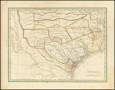
Republic of Texas
Fine dark impression of this early coast to coast map of the United States, issued just after the declaration of Independence for the Republic of Texas in 1836.
Marvelous large format map of the United States and the Republic of Texas. The map includes a marvelous treatment of the Western Territories of the United States, including a massive Neu-Californien, large "Oregan" Territory, extending to the Rocky Mountains, and large Missouri Territory, pre-dating the appearance of Nebraska Territory, Kansas, etc.
In this edition, a curious serpentine boundary is shown for the Republic of Texas, with many new placenames added for the first time, including:
- Houston
- Fort Houston
- Austin
- St. Antonio
- Bastrop
- Crockett
- Milam
- Refugio
- St. Augustine
- Beaumont
- Jasper
- Montgomery
- Texana
- Franklin
- Nashville
- Victoria
- Columbus
Upper California is shown in great detail, immediately before the explorations of John Fremont would eliminate the cartographic myths of the two large salt lakes (Timpanogos and Teguayo) and the river systems connecting each to the Pacific Ocean. In fact, this map is one of the most remarkably clear and bold depictions of these two mythical lakes and rivers, showing side by side with a relatively accurate and modern depiction of the Upper Colorado River, which had been explored for many years by Spanish missionaries, offering a stark contrast of the semi-explored regions of the West and those which were still virtually unknown.
In Oregon Territory, the river systems reflect the explorations of Lewis & Clark, the Hudson Bay Company outposts, etc.
![[United States] Index Map](https://storage.googleapis.com/raremaps/img/small/67626.jpg)
![(Humboldt Atlas and Text) Geographique et Physique du Royaume de Nouvelle-Espagne [with quarto text:] Essai Politique de la Royaume de la Nouvelle-Espagne](https://storage.googleapis.com/raremaps/img/small/99796.jpg)
![[First State of the Popple Key Sheet] A Map of the British Empire in America with the French and Spanish Settlements adjacent thereto by Hen. Popple.](https://storage.googleapis.com/raremaps/img/small/92714.jpg)
![Trails: [1595-1945]: Land, Sea, and Air of The American Adventure Series](https://storage.googleapis.com/raremaps/img/small/70672.jpg)