|
||

|

|
|

|
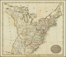
The United States with a Remarkable Texas Configuration
Rare 1849 Colton wall map of the United States, which features a massive "stovepipe" Texas configuration, on the eve of the Texas Compromise of 1850.
Another fascinating feature of the map is the treatment of the area called "Upper California" to the west of Texas. While the name New Mexico appears, there is a very distinct Mexico-Upper California boundary line south of El Paso del Norte, which would have put the town of El Paso on the Texas-California border.
The map shows Indian Territory, then populate by regions reserved for the Shawnee, Potawatamie, Wyandotte, Cherokee, Osage, Creek, Choctaw and Chickasaw Nations.
A massive Nebraska Territory extends to the Canadian border, with a number of Indian Nations named in the eastern part, along the Missouri River. The newly created Minnesota Territory is shown, which had just been formed in March 1849.
Texas Compromise of 1850
Under the compromise, Texas surrendered its claims to present-day New Mexico and other states in return for the United States Federal Government's assumption of Texas's public debt. California was admitted as a free state, while the remaining portions of the Mexican Cession were organized into New Mexico Territory and Utah Territory.
Rarity
The map is extremely rare.
We have been unable to locate another example of this map.
G. W. & C. B. Colton was a prominent family firm of mapmakers who were leaders in the American map trade in the nineteenth century. Its founder, Joseph Hutchins Colton (1800-1893), was a Massachusetts native. Colton did not start in the map trade; rather, he worked in a general store from 1816 to 1829 and then as a night clerk at the United States Post Office in Hartford, Connecticut. By 1830, he was in New York City, where he set up his publishing business a year later.
The first printed item with his imprint is dated 1833, a reprint of S. Stiles & Company’s edition of David Burr’s map of the state of New York. He also printed John Disturnell’s map of New York City in 1833. Colton’s next cartographic venture was in 1835, when he acquired the rights to John Farmer’s seminal maps of Michigan and Wisconsin. Another early and important Colton work is his Topographical Map of the City and County of New York and the Adjacent Country (1836). In 1839, Colton began issuing the Western Tourist and Emigrant’s Guide, which was originally issued by J. Calvin Smith.
During this first decade, Colton did not have a resident map engraver; he relied upon copyrights purchased from other map makers, most often S. Stiles & Company, and later Stiles, Sherman & Smith. Smith was a charter member of the American Geographical and Statistical Society, as was John Disturnell. This connection would bear fruit for Colton during the early period in his career, helping him to acquire the rights to several important maps. By 1850, the Colton firm was one of the primary publishers of guidebooks and immigrant and railroad maps, known for the high-quality steel plate engravings with decorative borders and hand watercolors.
In 1846, Colton published Colton’s Map of the United States of America, British Possessions . . . his first venture into the wall map business. This work would be issued until 1884 and was the first of several successful wall maps issued by the firm, including collaborative works with D.G. Johnson. From the 1840s to 1855, the firm focused on the production of railroad maps. Later, it published a number of Civil War maps.
In 1855, Colton finally issued his first atlas, Colton’s Atlas of the World, issued in two volumes in 1855 and 1856. In 1857 the work was reduced to a single volume under the title of Colton’s General Atlas, which was published in largely the same format until 1888. It is in this work that George Woolworth (G. W.) Colton’s name appears for the first time.
Born in 1827 and lacking formal training as a mapmaker, G. W. joined his father’s business and would later help it to thrive. His brother Charles B. (C. B.) Colton would also join the firm. Beginning in 1859, the General Atlas gives credit to Johnson & Browning, a credit which disappears after 1860, when Johnson & Browning launched their own atlas venture, Johnson’s New Illustrated (Steel Plate) Family Atlas, which bears Colton’s name as the publisher in the 1860 and 1861 editions.
J.H. Colton also published a number of smaller atlases and school geographies, including his Atlas of America (1854-56), his Illustrated Cabinet Atlas (1859), Colton’s Condensed Cabinet Atlas of Descriptive Geography (1864) and Colton’s Quarto Atlas of the World (1865). From 1850 to the early 1890s, the firm also published several school atlases and pocket maps. The firm continued until the late 1890s, when it merged with a competitor and then ceased to trade under the name Colton.
![(Texas Photograph) [Cabinet Card Birdseye View of El Paso, Texas and Ciudad Juarez]](https://storage.googleapis.com/raremaps/img/small/92983.jpg)