


|
||

|

|
|

|
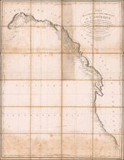
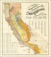
The First Comprehensive Geological Map of California
Fine large mineralogical map of California, published by the California State Mining Bureau.
The map was the result of an effort by the Trustees of the Mining Bureau, Harry I. Willey, as the former California Surveyor General and Julius C. Henkenius, who led the survey team and construction of the map. The Preliminary Mineralogical and Geological Map of the State of California, at a scale of 1:750,000 (12 miles equals one inch), was prepared and published in four sections by the California State Mining Bureau. Eight geologic units were depicted on the 1891 map, a significant improvement from all the previous geologic maps.
The map was issued by the State Mineralogist, William Ireland, but the map compiler is not credited on the map. However, the 10th Annual Report of the State Mineralogist (Irelan, 1890, p. 21) states that the topographical and other work on the Preliminary Geological and Mineralogical Map was "being executed by Mr. Julius Henkenius, who received aid in the geological and mineralogical locatings from the Field Assistants." A section of the report is excerpted at the end of this description.
The map is color coded to show the primary rock formation types, including:
- Granite (orange)
- Limestone (green)
- Auriferous Slates (blue)
- Volcanic Rocks (pink)
- Auriferous Gravels (gold)
- Metamorphic Cretacious (green dots)
- Unaltered Sandstones, Shales, Conglomerates (uncolored)
- Quaternary and Recent (yellow dots)
- Unexplored (blank)
A key below the rock formation types codes the 20 different types of mineral deposits shown on the map. A table at the bottom left identifies the altitudes of approximately 400 mountains and county locations given, with Mt. Whitney (15,000 ft) and Mt.Goddard (14,000 feet) as the tallest.
Below the title, a list of 551 Private Land Grants are noted. These are a complete and up to date list of the Spanish Land Grants which had been confirmed up to that date by the United States Government.
Report of the State Mineralogist
The following report which describes the publication of the map can be found in the Tenth Annual Report of the State Mineralogist:
I wish most particularly to call attention to the valuable data gathered by the Assistants in the Field; also, the masterly, comprehensive, and exhaustive special articles by several well known experts, under whose names they appear. H. I. Willey, ex-State Surveyor-General, was engineer in charge of the Preliminary Geological and Mineralogical Map, the topographical and other work thereon being executed by Mr. Julius Henkenius, who received aid in the geological and mineralogical locatings from the Field Assistants. San Francisco, Cal., October 4, 1890.
--Hon. Wm. Irelan, Jr., State Mineralogist:
. . . It having been your conclusion that the results of the work contemplated by you could, in many instances, best be presented to the public through the medium of a map, I have, as instructed by you, caused to be compiled from all available authentic sources a Topographical Map of this State. With this map as a basis, the several most important geological characteristics have been defined thereon in colors, and many of the metalliferous deposits indicated by symbols. . . . It has been difficult to define with exactness
the various geological characteristics, and the location of the different metalliferous deposits indicated on the map by symbols. The issuance of this map by counties, and upon a larger scale, as contemplated in the future, will enable you to more accurately and perfectly delineate and indicate these characteristics.It is to be hoped, however, that the map, as completed, will serve as a valuable reference to the people and scientists, both at home and abroad, and that subsequent appropriations will enable you to issue biennially an amended and corrected map, which will always be recognized as containing authentic information, and which in time will be as complete and attractive as that of any State in the Union.
There have been many difficulties to contend with in the compilation of the Topographical Map, owing to the errors and inaccuracies of surveys, but every effort has been made to eliminate and harmonize the same as much as possible. The principal difficulty has been encountered in the efforts to define the different county boundary lines. There are so many differences between the lines as described in the statutes and the location of the lines as claimed to exist upon the ground, that it is impossible to harmonize their differences and impracticable to correctly define any of these lines upon the map. It is to be hoped that upon a proper representation of the facts with relation to these lines to the Legislature of this State, they will make provision for the revision of the statutes describing these lines, and the proper running and defining of these lines in conformity therewith.
The Preliminary Geological Map of the State represents the result of the expenditure of a very considerable amount of money. By virtue of your position as ex officio State Engineer, and the custodian of the data in that office, it has been made possible in the compilation of the Preliminary Geological Map to give the public for the first time the results of an expenditure of $100,000 of the taxpayers' money. In order to utilize the maps of the State Engineering Department, it became necessary that the great State Map should be completed, which was done, with the exception of the correction of the county boundary lines, which, for reasons heretofore mentioned, could not be correctly defined thereon.
--Respectfully yours, HARRY I. WILLEY, Engineer.
Rarity
The map is very rare on the market. We note only a single example offered for sale in a dealer catalog or at auction (Warren Howell, 1979), who described the map as:
The first geological map published by the State Mining Bureau and the first comprehensive map of the geological and mineral areas of the state. The map was drawn by J.C. Henkenius to accompany the 10th Report of the State Mining Bureau, which included among its contributors such well-known geologists and engineers as H. W. Fairbanks, W. A. Goodyear, W. L. Watts, Ross E. Brown, and John Hays Hammond.