This item has been sold, but you can enter your email address to be notified if another example becomes available.


|
||

|

|
|

|
Stock# 70134
Description
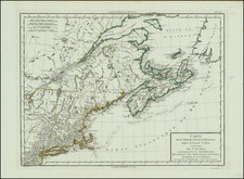
Striking map of New England, New York, Pennsylvania and New Jersey, from Bellin's scarce Le Petit Atlas Maritime, published in Paris in 1764.
While the title is similar, this map is double the size of the more common 1757 Bellin map of New England and the North East, and significantly rarer.
Includes detailed colonial borders, towns, rivers, lakes, bays, harbors, etc.
Reference
McCorkle, B.B. (New England) 764.1; Sellers & Van Ee #723 & 764.