
The item illustrated and described below is sold, but we
have another example in stock. To view the example which
is currently being offered for sale, click the
"View Details" button below.
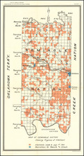
![[ Choctaw Nation ] Department of the Interior Commission on the Five Civilized Tribes Map of Choctaw Nation Indian Territory . . . 1904 By United States Department of the Interior](https://storage.googleapis.com/raremaps/img/small/70108.jpg)
1904 United States Department of the Interior
$ 245.00


|
||

|

|
|

|
Stock# 70080
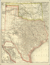
![[ Indian Territory / North Texas / Arkansas ] General Topographical Map. Sheet XXIV. Plate CLIX](https://storage.googleapis.com/raremaps/img/small/95113.jpg)
![[ Colorado ] [ Indian Territory on verso ]](https://storage.googleapis.com/raremaps/img/small/101102.jpg)