


|
||

|

|
|

|
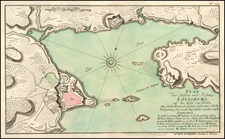
First State of the First North American City Plan
Fine example of Ramusio's map of Montreal, the first printed plan of a town in North America.
Jacques Cartier, the great French explorer, visited the village of Hochelaga on the island of Montreal in 1535. The village was near a mountain the explorer named Mount Royal or Monte Real. His account was published in the third volume of Ramusio's Delle navigationi et viaggi in 1556.
The map includes many of the things described by Cartier. The mythical large welcome is depicted in the clasping of hands by a Frenchman (presumably Cartier) and a native chief, and the advantage of two-story fortifications is demonstrated. The lodges within the fort are exceedingly symmetrical, but with each family unit indicated by a fire, they were probably intended to indicate that they were both single-family and multiple-family or extended family dwellings.
It is not clear who the Hochelagans were, although most likely either Huron or Iriquois. The village was gone by the time Champlain arrived.

![[Untitled Map of The Atlantic Ocean, Europe, Africa, the Middle East, and Eastern Canada]](https://storage.googleapis.com/raremaps/img/small/89582.jpg)
