


|
||

|

|
|

|
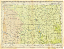
Rare birdseye view style map of the routes of the Union Pacific Railroad, published in 1880.
The main map focuses on the route of the Kansas Division of the Union Pacific, extending from Kansas City to the Front Range of the Rocky Mountains.
The map includes an excellent topographical treatment of the Rock Mountain Region of Colorado, locating a number of important mining towns, Wagon Roads and other details. A similar treatment of the towns, roads and rivers in the plains of Colorado and Kansas to the East. Topeka is shown in color.
From Denver, the line divides into a number of local lines, including:
- Cheyenne Division
- Colorado Division
- Denver & Rio Grande
- Denver, South Pacific & Pacific
On the verso, there are extensive promotional tracts promoting the most popular resorts and settlement opportunities in Colorado, along with promotional tract for Kansas.
Includes a stamp for C.C. Benson, Land Agent, Lewiston, Maine.
![[ Utah Territory and the Great Plains ] Maps / Stansbury's Expedition / Map of the Great Salt Lake and Adjacent Country in the Territory of Utah . . . (and) Map of a Reconnaissance between Fort Leavenworth on the Missouri River and the Great Salt Lake of Utah made in 1849 and 1850 . . .](https://storage.googleapis.com/raremaps/img/small/88490.jpg)
![Seeing Colorado [on verso] Part of the Route and Sightseeing Equipment of the](https://storage.googleapis.com/raremaps/img/small/88017.jpg)