|
||

|

|
|

|
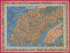
Interesting promotional map of the Eastern portion of Los Angeles County, likely published at about the time of the1932 Olympics.
The map is centered on Pasadena and the the San Gabriel Valley, stretching north to Lancaster and south to Artesia and Santa Fe Springs, with dozens of oil wells shown.
Gerald Allen Eddy moved from Michigan to Southern California in 1902.
From the 1920s, he worked in the Los Angeles area as an artist and commercial cartographer.
Eddy produced a number of pictorial and other maps of the western part of the United States. His earliest work was "Pushing Hun out of Franc eand Belgium" (1918). He produced several other war related maps during WWII, but is best known for his tourist and pictorial maps of California, Nevada and Arizona, including his "The Heart of Arizona" in 1926 and Boulder Dam map of 1931 and his iconic series of maps of Lake Tahoe.
![[Cambodia] Defend the People's Victory | Support the Khmer Rouge & the PRG](https://storage.googleapis.com/raremaps/img/small/85958.jpg)
![(Hollywood) [Annotated Real Estate Map of Hollywood]](https://storage.googleapis.com/raremaps/img/small/97362.jpg)