
The item illustrated and described below is sold, but we
have another example in stock. To view the example which
is currently being offered for sale, click the
"View Details" button below.


|
||

|

|
|

|
Stock# 70010
Description
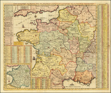
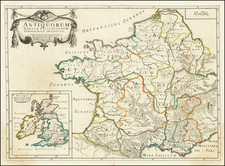
The Siege of Aire in 1710
A map of the siege of Aire (September 6-November 9, 1710, by the Allied army, commanded by John Churchill, 1st Duke of Marlborough (1650-1722), resulting in the surrender of the fortress by the French. War of the Spanish Succession (1701-14).
The map is oriented with north-north-west to top (compass rose).
Other commanders included Arnold Joost van Keppel, 1st Earl of Albemarle (1670-1718) and Leopold I, Prince of Anhalt-Dessau (1676-1747), who commanded the Prussian troops.
This large-scale map shows the detail of the fortified walls with the attack parallels, zig-zags and batteries, and the immediate surroundings.


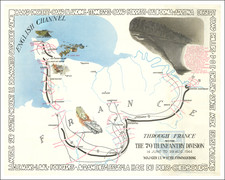
![(Second World War - D-Day - Omaha Beach) OMAHA BEACH-EAST (Colleville-sur-Mer) [:] FIRST BEACH OBSTACLE OVERPRINT [with:] OMAHA BEACH-WEST (Vierville-sur-Mer) [:] FIRST BEACH OBSTACLE OVERPRINT. NP, April 21, 1944 (with overprinting of information dated May 12).](https://storage.googleapis.com/raremaps/img/small/100123.jpg)