The item illustrated and described below is sold, but we
have another example in stock. To view the example which
is currently being offered for sale, click the
"View Details" button below.
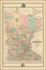
1867 Joseph Sewall
$ 750.00


|
||

|

|
|

|
Stock# 70004
Description
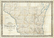
Scarce St. Paul-published pocket map of Minnesota depicting the state from the Lake of the Wood to the Iowa border. The map extends eastward towards Wisconsin's Bayfield Peninsula.
Sewall was publishing maps out of St. Paul at the time of statehood. The present map was prepared at that time or a little thereafter - the county configuration dates it to circa late 1858. Contemporary evidence suggests that although the imprint date is 1857, this map was published in 1860.
Condition Description
Folding map with original covers. Several fold splits. Minor toning along centerfolds.
Reference
Rumsey 2381, Phillips, A List of Maps of America, p. 433; Graf 3735; Streeter Sale 3928 (1867 issue); Eberstadt 163:356; Karrow 7-0716 (1857 issue).

![Diagram showing ceded and reserved Chippewa lands in Minnesota [with:] In the Supreme Court of the United States. October Term, 1912.](https://storage.googleapis.com/raremaps/img/small/93674.jpg)