|
||

|

|
|

|
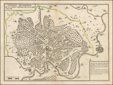
Rare large plan of Paris by Jouvin de Rochefort, published by Nicolas de Fer in 1694.
Rochefort's map is of note as the second map to present Paris in a North-South axis, with the Seine being illustrated horizontally.
The plan shows the city's five successive enclosed walls, from that of Clovis to that of Louis the Great, still under construction, and places them for the first time in parallel with the new boulevards of Louis XIV. The improved parts of Paris are shaded with fine and regular lines, which is an innovation, distinguishing these areas from the surrounding farm and other lands on the periphery.
The map is decorated with small cartouches representing the major Parisian monuments:
- Notre-Dame
- Val de Grâce,
- Sorbonne
- Observatory (with an astronomer using an astronomical telescope)
- plan of a barracks (with a seated soldier, carrying a standard).
On the left, alphabetical table of streets, on the right, alphabetical table of churches, convents, colleges, hotels, etc.
French cartographer, Jouvin de Rochefort was also treasurer of France from 1675 to 1702. A great traveler, he is the author of a story in which he describes his own journeys which took him through Europe, then to Egypt.
This is the original De Fer map. The map was re-issued by Covens & Mortier in abut 1708, with
Rarity
De Fer's map is rare on the market, this being the first example we have ever offered for sale.
Nicholas de Fer (1646-1720) was the son of a map seller, Antoine de Fer, and grew to be one of the most well-known mapmakers in France in the seventeenth century. He was apprenticed at twelve years old to Louis Spirinx, an engraver. When his father died in 1673, Nicholas helped his mother run the business until 1687, when he became the sole proprietor.
His earliest known work is a map of the Canal of Languedoc in 1669, while some of his earliest engravings are in the revised edition of Methode pour Apprendre Facilement la Geographie (1685). In 1697, he published his first world atlas. Perhaps his most famous map is his wall map of America, published in 1698, with its celebrated beaver scene (engraved by Hendrick van Loon, designed by Nicolas Guerard). After his death in 1720, the business passed to his sons-in-law, Guillaume Danet and Jacques-Francois Benard.
![[Paris Environs - Southeast] Carte Routiere pour Automobilistes & Cyclistes -- Environs de Paris Section Sud-Est](https://storage.googleapis.com/raremaps/img/small/95862.jpg)
![[ Paris ] Plan Routier De La Ville et Faubourg De Paris 1772](https://storage.googleapis.com/raremaps/img/small/92313.jpg)