


|
||

|

|
|

|
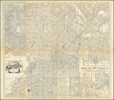
Rare promotional pictorial map of "Jewish Los Angeles," providing a whimsical look at Great Los Angeles and its various Jewish businesses, schools, temples and other public and private institutions.
The map includes a directory of businesses and organizations with phone numbers below the map -- likely the paid advertisers who sponsored the map.
The following article about the map appeared in the Los Angeles Times, written by Glen Creason, in December 17, 2014
CityDig: We Like This Map of Jewish L.A. a Whole Latke
With menorahs being lit and “Barukh atah…” prayers being recited all over town, it seems only appropriate to celebrate the Jewish contingent of Los Angeles via map. I wish I could say more about Bill Block and this sweet pictorial of the many facets of L.A. Judaica, but I can only tip a yarmulke to the artist and researchers who put this one together. Certainly Jews have been a big part of Los Angeles from as early as the Mexican colonial pueblo and Jacob Frankfort, who joined the ciudad de Los Angeles in 1841. In the first U.S. census there were only eight Jews in the count, but by 1854, services were being conducted by Joseph Newmark (a lay rabbi). By 1862 the Hebrew Benevolent Society (the first charity in L.A.) and a Jewish cemetery up in Elysian Park had been founded, and Temple B’nai B’rith had been built at Temple and Broadway. That synagogue in particular moved to 9th and Hope in 1895 and eventually settled at Wilshire and Western, where the magnificent Wilshire Boulevard Temple thrives to this day.
Meanwhile, over in Boyle Heights, the Pioneer Lot Association was formed around 1865 and a long tradition of Jews living east of the LA River began. Isaias Hellman established the Farmers and Merchants Bank by 1868, and other Jews were prominent in utilities, streetcar systems, retail stores, public schools, and even the public library. While there was no delineated “Jewish neighborhood,” around 2,500 Jews lived in the general downtown area after the turn of the 20th century. A great influx in Boyle Heights and Hollywood increased the size of congregations: Congregation Talmud Torah (known as the Breed Street Shul) flourished on the East side with its population growing to 65,000. By 1940, Los Angeles had the seventh largest Jewish community in America, and by 1950, the population had increased to over 300,000, with many families moving from Boyle Heights to the West Side, the Valley, and the Fairfax district (affectionately known as “the Borscht Belt”).
This 1990 map demonstrates the influence of the Jewish community on the Los Angeles landscape with places of culture and worship abounding. Higher education is offered at Yeshiva University, Hebrew Union College, and the Hebrew University along with preparatory education at the Steven Wise School. We see the Jewish Historical Society and the Simon Wiesenthal Center with the inspiring Museum of Tolerance. From Malibu to the San Fernando Valley and from South Park to Elysian Park, the benevolent and positive role of the Jewish people in L.A. is evidenced on the landscape, including Dodger Stadium, where Sandy Koufax (“the best Jewish athlete since Samson,” according to George Jessel), pitched for our beloved boys in blue.
Rarity
We have never seen the map before. The only reference to the map is the illustration in the above referenced newspaper article, from the collection of the Los Angeles Public Library.
![(Hollywood) [Annotated Real Estate Map of Hollywood]](https://storage.googleapis.com/raremaps/img/small/97362.jpg)
![[ East Los Angeles / Bristow Park ] New Belvedere Gardens and Union Pacific Industrial Tract](https://storage.googleapis.com/raremaps/img/small/97922.jpg)