|
||

|

|
|

|
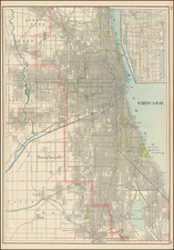
Rare Variant of Blanchard's Fine Post-Fire Map of the City of Chicago
A scarce folding lithographed map of Chicago, colored by wards, by one of Chicago's foremost 19th-century map publishers.
The present example has been overprinted in red, with the key noting that the red overprinting shows:
- City Limits -- Heavy red line
- Wards -- dashed red line
- Fire limits -- thin red line
In addition, the recently completed Crystal Palace is also overprinted in red, with a note that it is "To be Completed September 1st 1873 for the Great Exposition." The red overprinting is also used to highlight parks and major roads connecting the parks in the west.
The map image is bounded by Fullarton Avenue in the north, Lake Michigan in the east, Crawford Avenue in the west, and Forty-Second in the south.
The map shows considerable detail of the railroads and streets, and names some buildings, including railway stations. Parks are highlighted in green.
![Illinois [and Southwestern Wisconsin]](https://storage.googleapis.com/raremaps/img/small/84717.jpg)
![[ Mississippi River Atlas ] Theorie der Bewegung des Wassers in Flüssen und Canälen. . . . (Atlas Volume)](https://storage.googleapis.com/raremaps/img/small/101700.jpg)