|
||

|

|
|

|
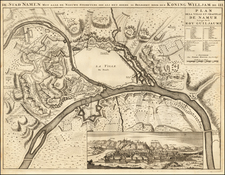
A Grand Battle Plan From the War of Austrian Succession
Fine 2 sheet map of the area around Bergen-op-Zoom, illustrating the region at the time of its Siege in 1747.
Oriented with east at the top, the 2 sheet map shows the town and fortifications of Bergen op Zoom and the important fortifications to the north which aided in its defense.
Considered one of the strongest fortifications in the Dutch Netherlands, its fall in September 1747 was one of the final battles of the war.
The Siege of Bergen op Zoom took place during the Austrian War of Succession, when a French army, under the command of Lowendal and the overall direction of Marshal Maurice de Saxe, laid siege and captured the strategic Dutch border fortress of Bergen op Zoom on the border of Brabant and Zeeland in 1747. The fortress was defended by Dutch, Austrians, British, Hanoverians and Hessians that supported the Pragmatic Sanction.
After seven years of war, both sides in this conflict were suffering from weariness of the war. Although tentative peace initiatives had been put forward, neither side was yet willing to make meaningful concessions. The capture of Bergen op Zoom signaled defeat for the Dutch and would open the door for an invasion of the Dutch Netherlands. The siege was the center of attention in Europe and news of it followed eagerly in numerous reports with the Pragmatic allies confident that the fortress would withstand the French and the French determined it should fall.
Following his victory at the Battle of Lauffeld, the French Marshal de Saxe detached a force 30,000 under the command of General von Lowendal to lay siege to Bergen op Zoom. Needing to protect Maastricht from the threat posed by De Saxe's forces, neither the British commander, the Duke of Cumberland, nor the Austrian commander, Batthyány, felt able to move to support Bergen op Zoom. For the Dutch this proved the unwillingness of her allies to assist them in their time of need, while their British allies felt the Dutch demands for greater allied effort in this war was absurd - reasoning that the Dutch had not formally declared war on France.
Bergen op Zoom was a fortress town with a population of some 5,000 people and an initial garrison of 3,000 under the command of the 86-year-old, vigorous Governor General Cronström. The circumference of the fortress ramparts was about three miles with ten bastions covered by five hornworks. The intervals contain twenty one ravelins which are covered by stone lunettes. Much of the surrounding country was marshland. Additionally, an entrenched camp at Roosendaal, defended by three forts: Moermont, Pinsen, Rovers, and trench lines connecting to the city on the northeast, were held by the Prince of Hildburghausen with 20 battalions of infantry and 14 squadrons of cavalry that could reinforce or relieve the garrison. Because of these lines and some lesser lines to the west, Bergen op Zoom could not be completely invested, or surrounded. Further, because of the low-lying ground, large areas fronting the defenses were inundated by the Dutch using various sluices and channels and this prevented any French approach in those parts of the field. The fortress was the chief work of the great Dutch engineer, Menno van Coehoorn. Bergen op Zoom had withstood two previous sieges, the first in 1588 and a second in 1622. It could be supplied with munitions and provision by boats using two navigable canals each defended by its own fort.
The Siege began on July 14, 1747 and ended with a massive push on September 18, 1747.
The defeat caused a rift between the Dutch and British governments. It now dawned on the British that they had demanded too much of the military capability of the Dutch Republic and that its ability to resist the French had been exhausted. The Dutch on the other hand were furious about the fact that her allies were unwilling to relieve the city. The city was key to opening up the Dutch Republic and Hanover to a potential French invasion. Lowendal was made a Marshal of France for his exploit.
Along with the defeat at Lauffeld, the defeat at Bergen op Zoom forced the British to re-enter negotiations, and to take seriously the ongoing talks at the Congress of Breda, leading to a treaty in 1748.
Matthäus Seutter (1678-1757) was a prominent German mapmaker in the mid-eighteenth century. Initially apprenticed to a brewer, he trained as an engraver under Johann Baptist Homann in Nuremburg before setting up shop in his native Augsburg. In 1727 he was granted the title Imperial Geographer. His most famous work is Atlas Novus Sive Tabulae Geographicae, published in two volumes ca. 1730, although the majority of his maps are based on earlier work by other cartographers like the Homanns, Delisles, and de Fer.
Alternative spellings: Matthias Seutter, Mathaus Seutter, Matthaeus Seutter, Mattheus Seutter
![Mechlinia [Mechelen]](https://storage.googleapis.com/raremaps/img/small/80595.jpg)