|
||

|

|
|

|
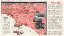
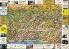
The First Subdivision Map for Huntington Palisades and Pacific Palisades
Rare separately published sub-division map, showing the development for Pacific Palisades and Huntington Palisades, in West Los Angeles.
This would seem to be one of the earliest printed maps to show the full extent of the Palisades, at the time the first lots were marketed for sale by the Santa Monica Land & Water Company in 1926.
The map covers the lands on either side of Sunset Boulevard (here simply referenced as Boulevard), covering several miles of the coastline centered on Will Rogers State Beach. The subdivision is spread out on either side of Temescal Canyon, pre-dating the paving of Temescal Canyon Road. At the corner of Sunset Blvd, Chatauqua and Pampas Ricas Blvd, a manuscript note identifies the location of an "office," almost certainly the office of one of the early real estate companies subdivision.
Chautauqua Assembly Camp
The map provides a lot by lot and street by street look at the Palisades, including an athletic field, Gymnasium and Tennis Courts. These would appear to be the facilities of the Chataqua Assembly Camp, established in Pacific Palisades in 1922. The Chautauqua movement was a protestant movement which included summer camps for adults with a religious, intellectual and recreational component. an adult education and social movement in the United States, highly popular in the late 19th and early 20th centuries. Chautauqua assemblies expanded and spread throughout rural America until the mid-1920s. The Chautauqua brought entertainment and culture for the whole community, with speakers, teachers, musicians, showmen, preachers, and specialists of the day.
Santa Monica Land & Water Company
The Santa Monica Land & Water Company was incorporated February 23, 1897 as a land company tasked with developing about 50,000 acres of land located in what is now West Los Angeles.
Huntington Palisades
The history of the Huntington Palisades begins with Abbott Kinney. In 1887 Kinney established the nation’s first forestry station in Rustic Canyon. In 1887, Kinney purchased 247 acres of land on the bluffs north of Santa Monica Canyon from the Marquez family to be developed as “Santa Monica Heights.” By 1888, Kinney abandoned his plans and sold the entire property to Collis Huntington, uncle of Henry Huntington.
Envisioning a great seaport at the mouth of Potrero Canyon, Huntington made plans to establish his private estate on the bluffs above Santa Monica Canyon. He built a wharf extending 4,720 feet out into the ocean , which handled more than 300 vessels during its first year of operation. When the decision was made to establish the port of Los Angeles in San Pedro and with the death of Collis Huntington and a deteriorating housing economy, his heirs sold the entire 226 acres in 1926 to Robert C. Gillis.
Gillis was president of the Santa Monica Land and Water Company, whose large-scale land purchases set the pattern for subdivisions from Westwood to Pacific Palisades. Gillis named the new suburb “Huntington Palisades” and planned to transform it into a fashionable upper middle-class community. Gillis chose a romantic scheme of curved streets and landscaped boulevards. Concentric semi-circular drives surrounded an open park are (bounded by El Cerco Place) and intersected a broad entry street with landscaped central parkways (Pampas Ricas). The design reflected the high standards set by Gillis and Reverend Robert Scott (founder of Pacific Palisades and president of the Pacific Palisades Founders Association). The design included elements characteristic of the Olmstead brothers, who also laid out New York’s Central Park. The elder Olmstead brother, Frederick, had come to Los Angeles to help in planning Palos Verdes and he was hired to help in designing the Huntington.
The development of the Huntington Palisades was left to Mark Daniels and W.W. Williams. Underground utilities were installed and ornamental light fixtures were provided, costing four times the normal amount for such services. Street names were chosen by the project engineer, W.W. Williams, who named them after famous places and people in Mexico, where he had spent much of his mining career. Alma Real was named for his lady friend, a singer and dancer from Mexico. Toyopa was the name of a lost mine in Sonora, Mexico. Chapala is the name of the largest lake in Mexico. Corona del Mar means “crown of the sea” in Spanish. The initial buyers of the various lots were also offered access to a three hundred foot stretch of private beach and membership in the new neighborhood association. The opening ceremonies for the development were held on January 20, 1926. The first home, a 12 room colonial located at 601 Ocampo Drive, was completed before the end of 1926 and is still standing today.
Rarity
The map is unrecorded.
OCLC does locate a single tract map for tract number 9377 of Huntington Palisades, dated June 1926, but no other related maps.
![[ Norma Triangle / West Hollywood / Sunset Strip / Santa Monica Blvd ] Map of West Knoll Los Angeles County, California](https://storage.googleapis.com/raremaps/img/small/97769.jpg)