


|
||

|

|
|

|
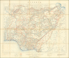
An Exceptionally Detailed Map of Nigeria
Detailed map of Nigeria, first published by the British War Office in 1910, with revisions and additions to this example up to July 1921.
Published in aid of the British Colonial administration, the map provides a finely detailed look at Nigeria during the period when the British were consolidating their control over the region.
In addition to the plethora of provincial and district names (in red) and the tribal names (in green), the map reference key identifies:
- International Boundaries
- Internal Colonial Boundaries
- Administrative District Boundaries
- Railways (completed and proposed)
- Tramways
- Major and Minor Roads in the Northern and Southern Provinces
- Boundaries of Mandate areas
- Roads in Southern Provinces
- Paths
- Telegraphs
- Telegraphs along roads
- Ruins
At the eastern edge of the map, the French Mandatory Territory (Cameroon) is shown.
British Nigeria
In 1885, British claims to a West African sphere of influence received recognition from other European nations at the Berlin Conference. The following year, it chartered the Royal Niger Company under the leadership of Sir George Taubman Goldie.
By the late 19th and early 20th centuries, the company had vastly succeeded in subjugating the independent southern kingdoms along the Niger River, the British conquered Benin in 1897, and, in the Anglo-Aro War (1901–1902), defeated other opponents. The defeat of these states opened up the Niger area to British rule. In 1900, the company's territory came under the direct control of the British government and established the Southern Nigeria Protectorate as a British protectorate and part of the British Empire, the foremost world power at the time.
By 1902, the British had begun plans to move north into the Sokoto Caliphate. Lord Frederick Lugard a British general, was tasked by the Colonial Office to implement the agenda. Lugard used rivalries between many of the emirs in the southern reach of the caliphate and the central Sokoto administration to prevent any defense as he worked towards the capital. As the British approached the city of Sokoto, the new Sultan Muhammadu Attahiru I organized a quick defense of the city and fought the advancing British-led forces. The British force won, sending Attahiru I and thousands of followers on a Mahdist hijra. In the northeast, the decline of the Bornu Empire gave rise to the British-controlled Borno Emirate which established Abubakar Garbai of Borno as the ruler.
In 1903, the British-victory in the Battle of Kano gave them a logistical edge in pacifying the heartland of the Sokoto Caliphate and parts of the former Bornu Empire. On March 13, 1903, the last Vizier of the Caliphate officially conceded to British rule. The British appointed Muhammadu Attahiru II as the new Caliph. Fredrick Lugard abolished the Caliphate, but retained the title Sultan as a symbolic position in the newly organized Northern Nigeria Protectorate. This remnant became known as "Sokoto Sultanate Council". In June 1903, the British defeated the remaining forces of Attahiru I and killed him; by 1906 resistance to British rule had ended.
On 1 January 1914, the British formally united the Southern Nigeria Protectorate and the Northern Nigeria Protectorate into the Colony and Protectorate of Nigeria. Administratively, Nigeria remained divided into the Northern and Southern Protectorates and Lagos Colony. Inhabitants of the southern region sustained more interaction, economic and cultural, with the British and other Europeans owing to the coastal economy.
Following World War II, in response to the growth of Nigerian nationalism and demands for independence, successive constitutions legislated by the British government moved Nigeria toward self-government on a representative and increasingly federal basis. Nigeria achieved independence in 1960.
Rarity
The map is quite rare. OCLC locates only 2 examples.

![[Northern Nigeria Protectorate]](https://storage.googleapis.com/raremaps/img/small/70705.jpg)
![[ Sierra Leone to Côte d'Ivoire ] Pas-caert vande Gryen-Cust en Adaows Qua Quaas Tuhessen de Serraliones en C. de Tres Puntas . . . .](https://storage.googleapis.com/raremaps/img/small/99332.jpg)