


|
||

|

|
|

|
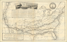
Restricted Military Map of San Diego
Restricted Armed Forces edition of this World War II era map of San Diego, published by the Automobile Club of Southern California.
As noted below the map, the map was "issued for the exclusive use of the Armed Forces of the United States," and "contains information affecting the national defense of the United States within the Espionage Act, 50 U.S.C. 31 and 32, as amende. Its transmission or the Revelation of its contents in any manner to an unauthorized person is probibited by law."
This is an example of a Civilian map repurposed for military use. Specifically highlighting the water lines, coded by the size of the line, including 4 inch, 6 inch, 8 inch, 12 inch and 16 inch lines, along with a blue line illustrating a 16 inch proposed line from Mission Valley to La Mesa.
The map shows schools, golf courses, parks, post offices,the Mission Valley Polo Fields.
Rarity
The map is apparently quite rare. This is the first example we have ever seen.
![[San Diego & Vicinity] Home Federal Country](https://storage.googleapis.com/raremaps/img/small/71369.jpg)
![(Second World War - Okinawa) [Large Battlefield Composite Map of Okinawa]](https://storage.googleapis.com/raremaps/img/small/63896.jpg)
![(Second World War - Holocaust) Walki z najezdzca Hitlerowskim I zbrodnie Hitlerowskie na terenie wojewodztw: Bialostockiego, Lomzynskiego i Suwalskiego w latach 1939-1945 [Fights with the Nazi invaders and Nazi crimes in the following voivodeships: Bialostocki, Lomzynskie and Suwałki in 1939-1945]](https://storage.googleapis.com/raremaps/img/small/82911.jpg)